Canyons, Cadillacs, and Caravans

We spent several days in Amarillo, Texas. There is more to do there than we had thought!

General Texas Thoughts

We enjoyed our time in Texas, starting with our stop at the I-40 Welcome Center as we crossed in from Oklahoma.

Texas does things BIG!

And we had some reminders that we “aren’t in Kansas” (i.e., Maine) anymore!

Well… Maybe we ARE in Kansas, Toto!

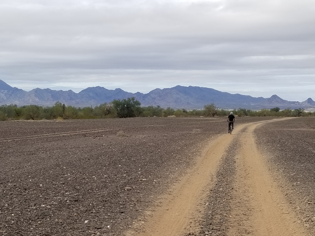
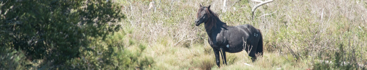
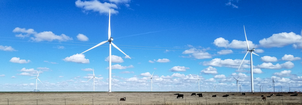
Texas is the state with by far the largest wind power capacity, about 22.6 gigawatts, as of 2017.  And they’re still building. There are wind turbine “farms” seemingly everywhere! Go, renewable power!  What you can’t see in any picture is that these farms go on for miles. They are beautiful and quite mesmerizing.
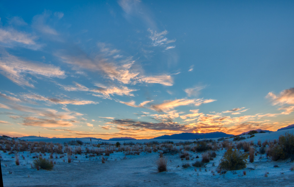
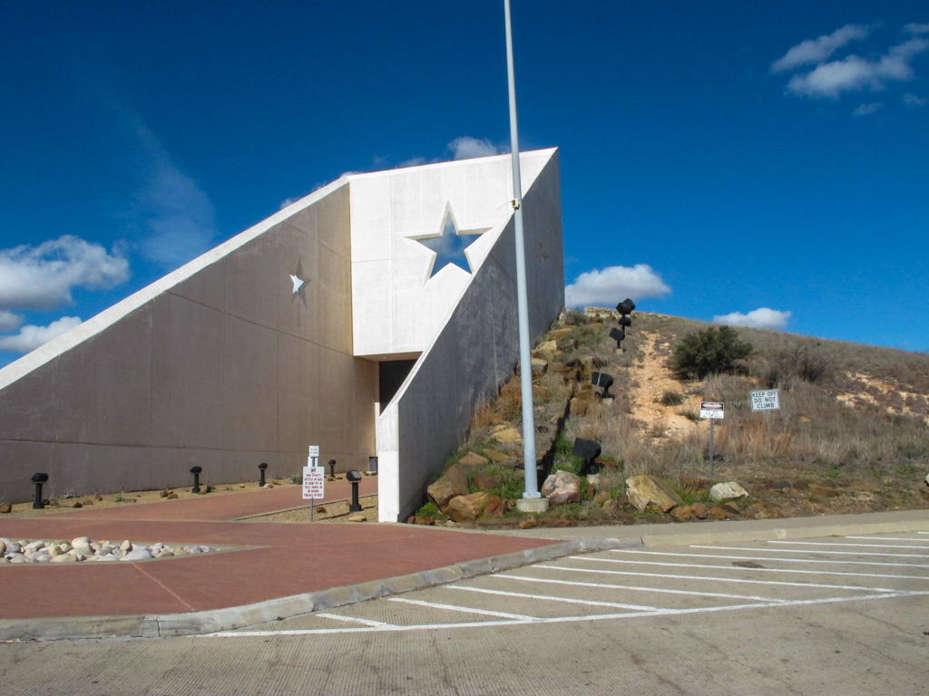
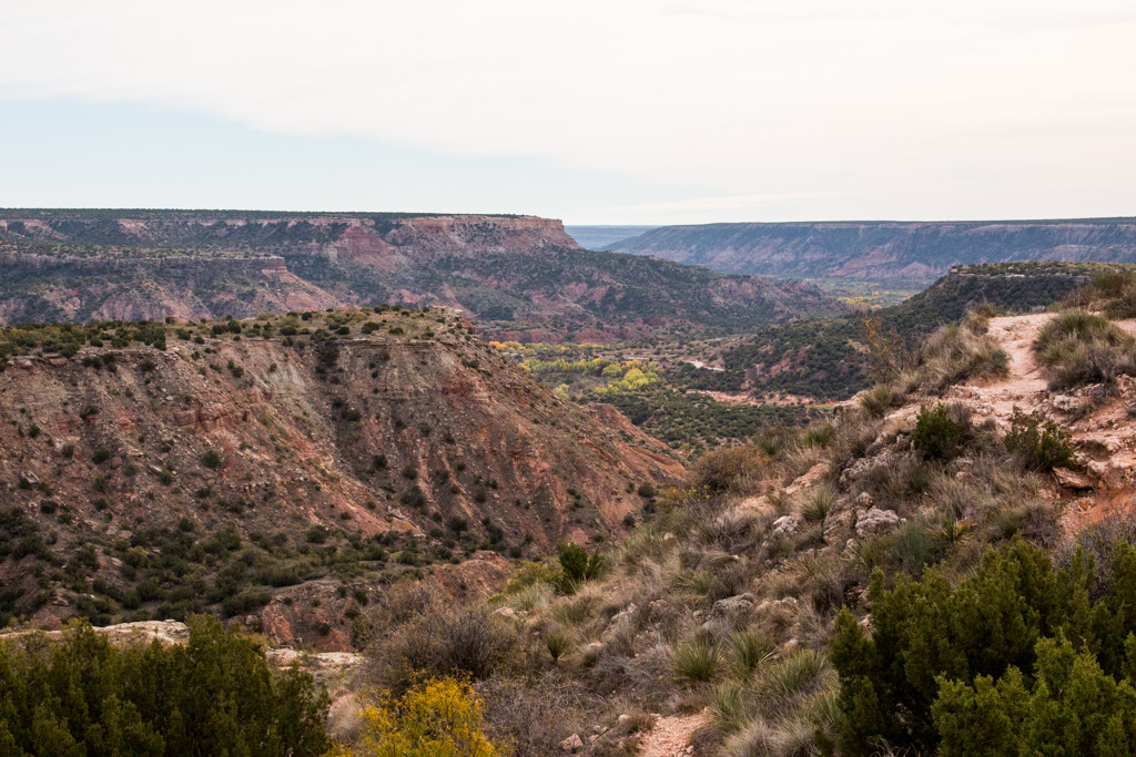
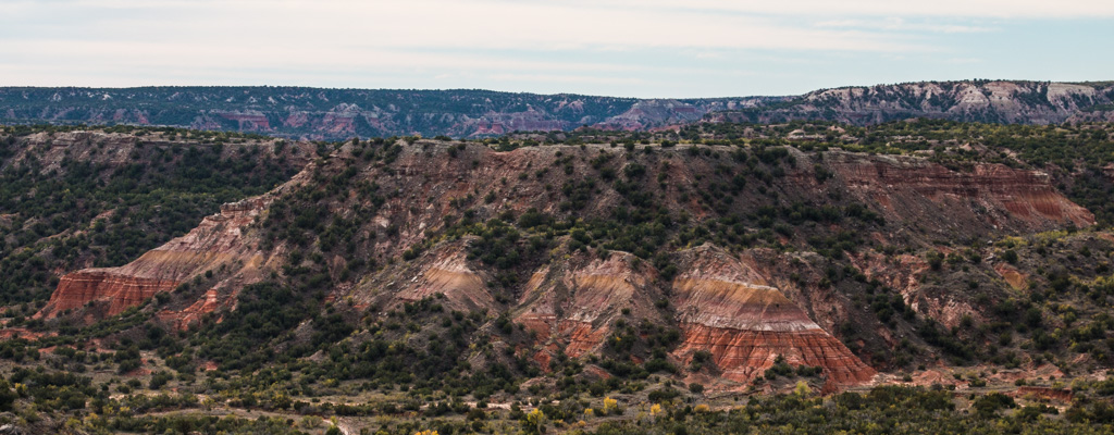
Palo Duro Canyon

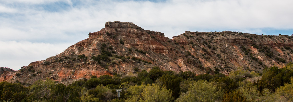
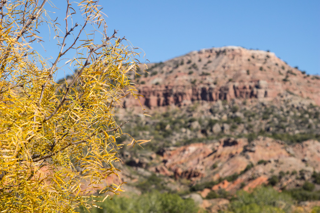
When you’re looking at the Palo Duro Canyon, don’t try to compare it to the Grand Canyon.  If you do, you will do yourself a disservice and miss the beauty here.

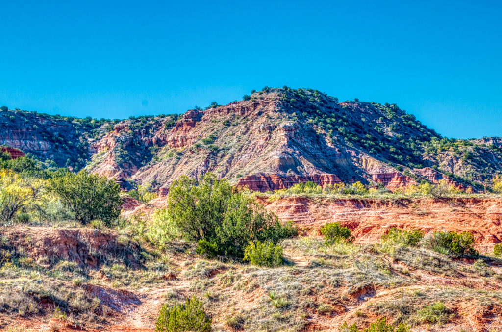
Palo Duro is the second-largest canyon in the country, and has its own beauty to explore.

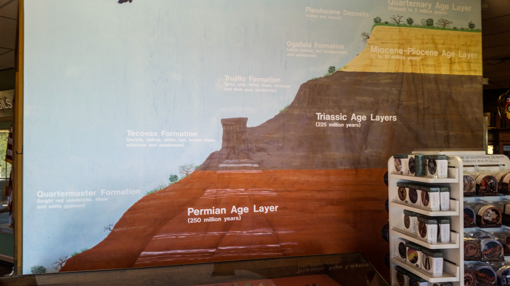
The colors in the layers indicate how old the layer is.  The panhandle of Texas was once a seabed, and this stone was laid down across millenia.

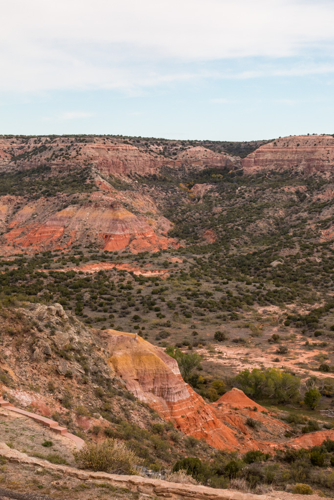
Unlike the Grand Canyon, Palo Duro has a road to the bottom of the canyon.  There are campgrounds down there and people bring their large RVs.  We went to the bottom, but I’m very glad that we weren’t pulling Rhett!

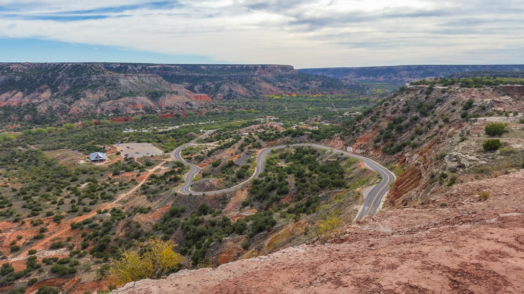
Take a look around the canyon!


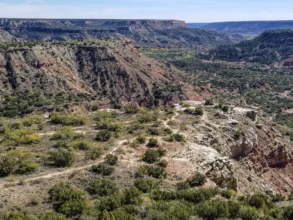
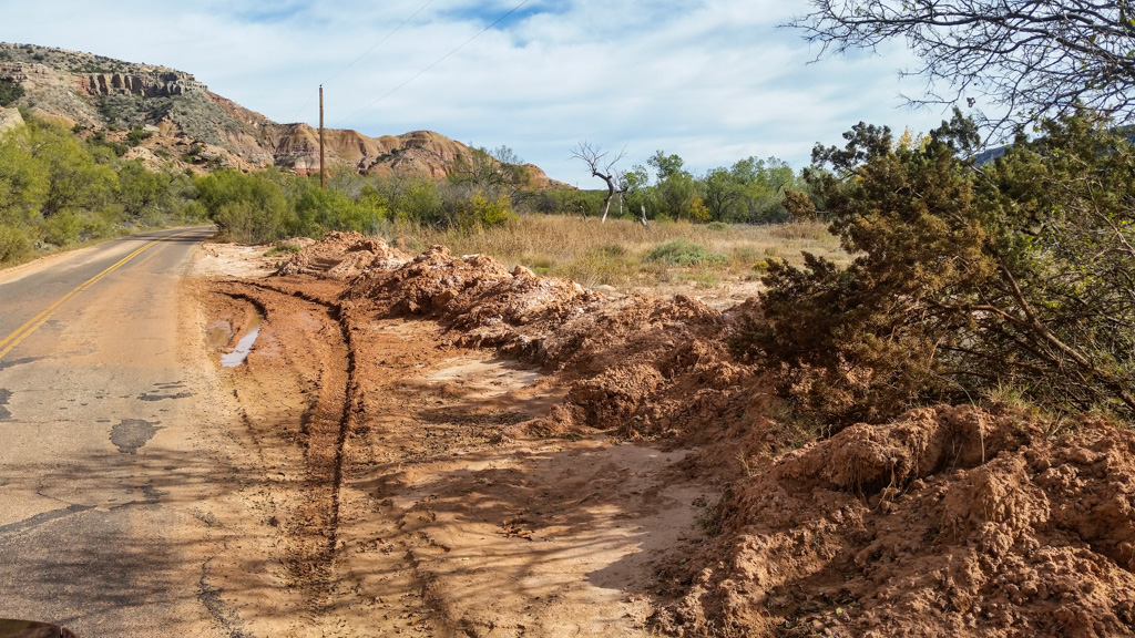
The canyon is still being formed by the action of the river.  The day we were there, the river was about 6 feet wide and flowing slowly.

However, flash flooding is a big problem.  Wherever the road crossed the river there were flood gauges at each end of the bridge, measuring road flooding up to 5 feet above grade.  And the bridges were 15 to 20 feet above the river!

They don’t need to shovel snow here (at least very often), but they have a lot of work clearing the road after a flash flood!
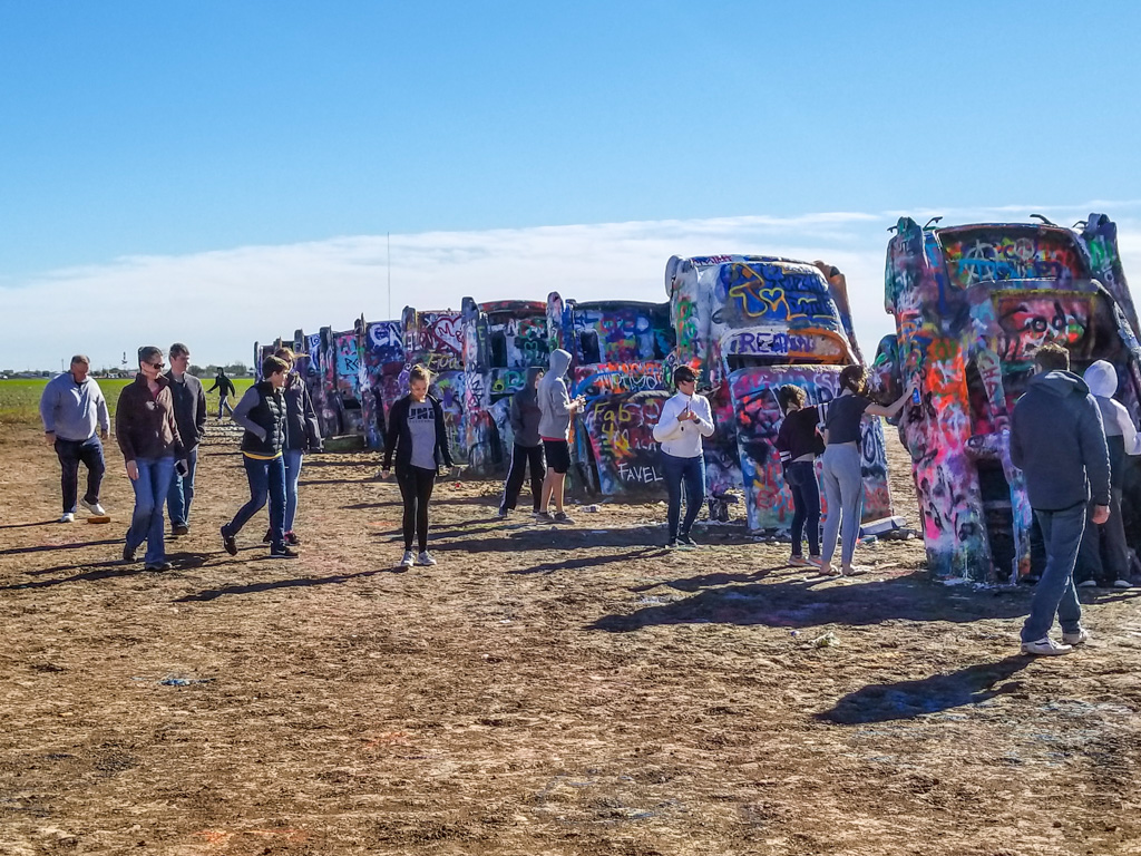
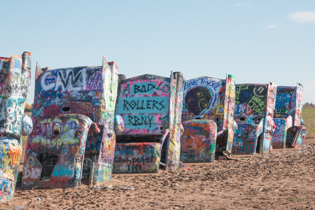
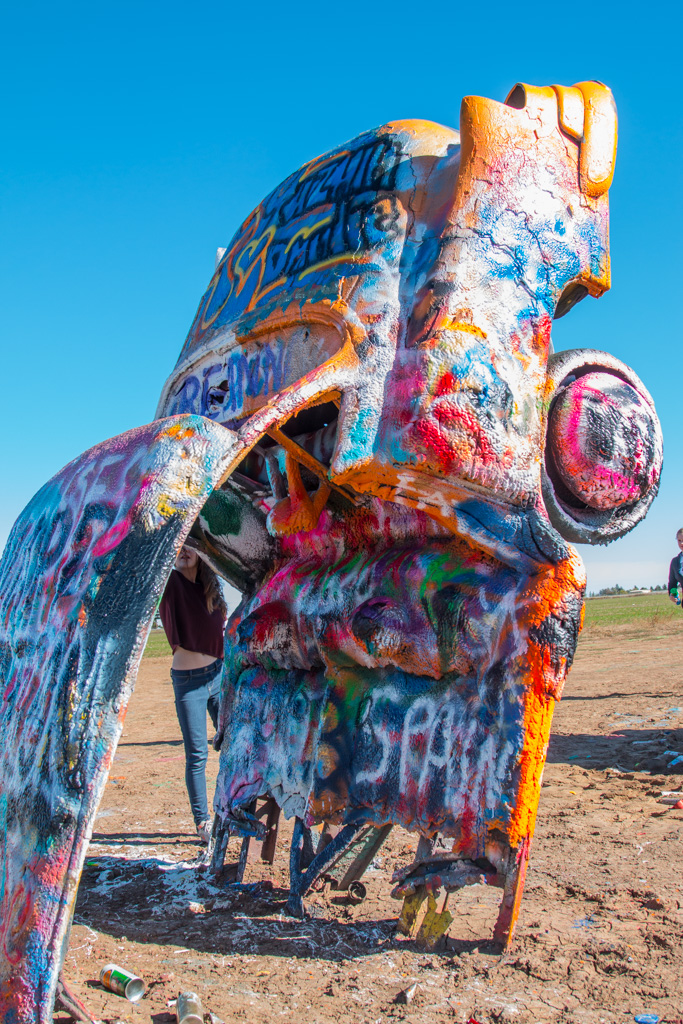
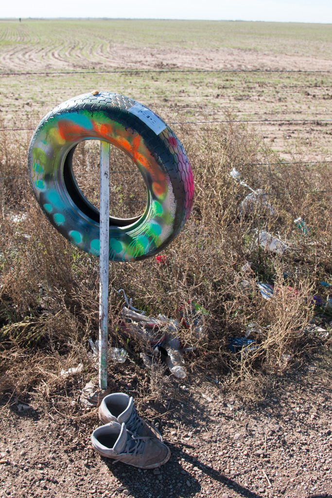
“Snow” shoveling after a flood…

Cadillac Ranch

You’ve probably heard about this unusual place, where some artists buried eight Cadillacs nose-down with the backs of the cars sticking up.

It was nearby, so… Why not?

We didn’t realize that it was an ongoing art project, encouraging people to contribute by spray painting the cars!  It was fun to see the cumulative effect—wow!
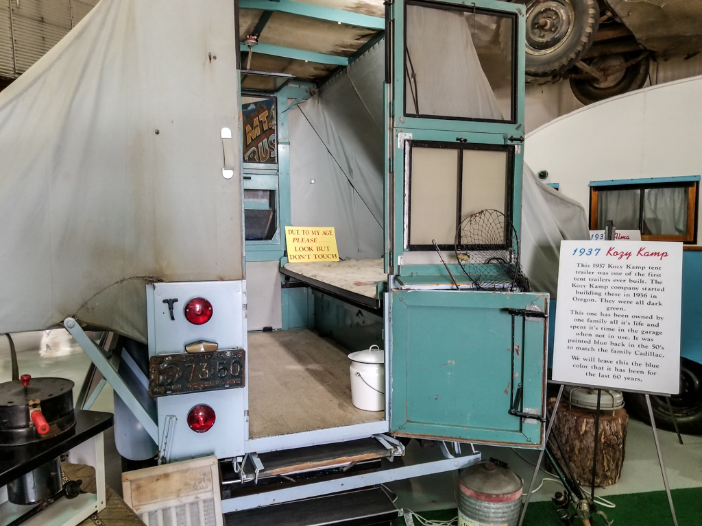
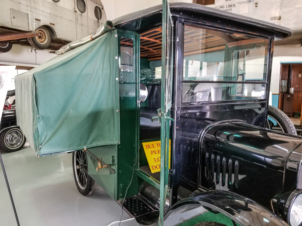
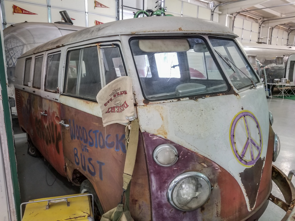
Some people sprayed expanding foam as well as paint.

RV Museum

We didn’t know about this one ahead of time… Jack Sisemore, the owner of an RV dealership in town, created an RV museum.  It was highly recommended to us by the folks at the next campsite (who happened to be from NH!). I expected a small garage with a few RVs in it.

WRONG!

This is a serious museum of the history of RVing, containing many firsts or only remaining examples of units.

The oldest Airstream, 1935.
One of the first tent trailers. We spent many happy vacations in its descendants!
Another tent-extended camper.
The unit from the Robin Williams movie, “RV”.
Itasca by WInnebago. Serial number 1.
What would an RV museum be without a VW microbus? Al’s family went camping through the Canadian maritime provinces in one of these in the 60’s.

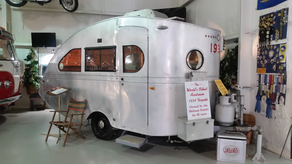
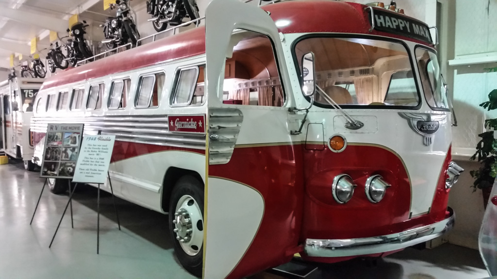
I didn’t know until we were in the museum that Jack had started the Keystone company, one of the behemoths in the RV industry, in 1996.

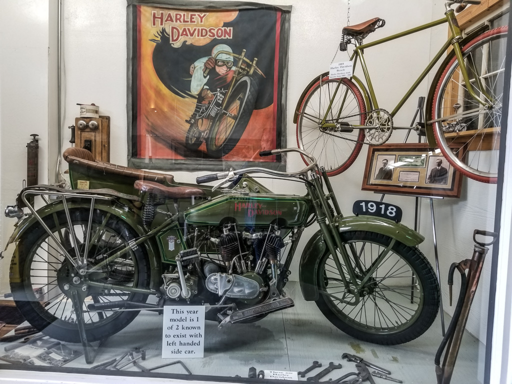
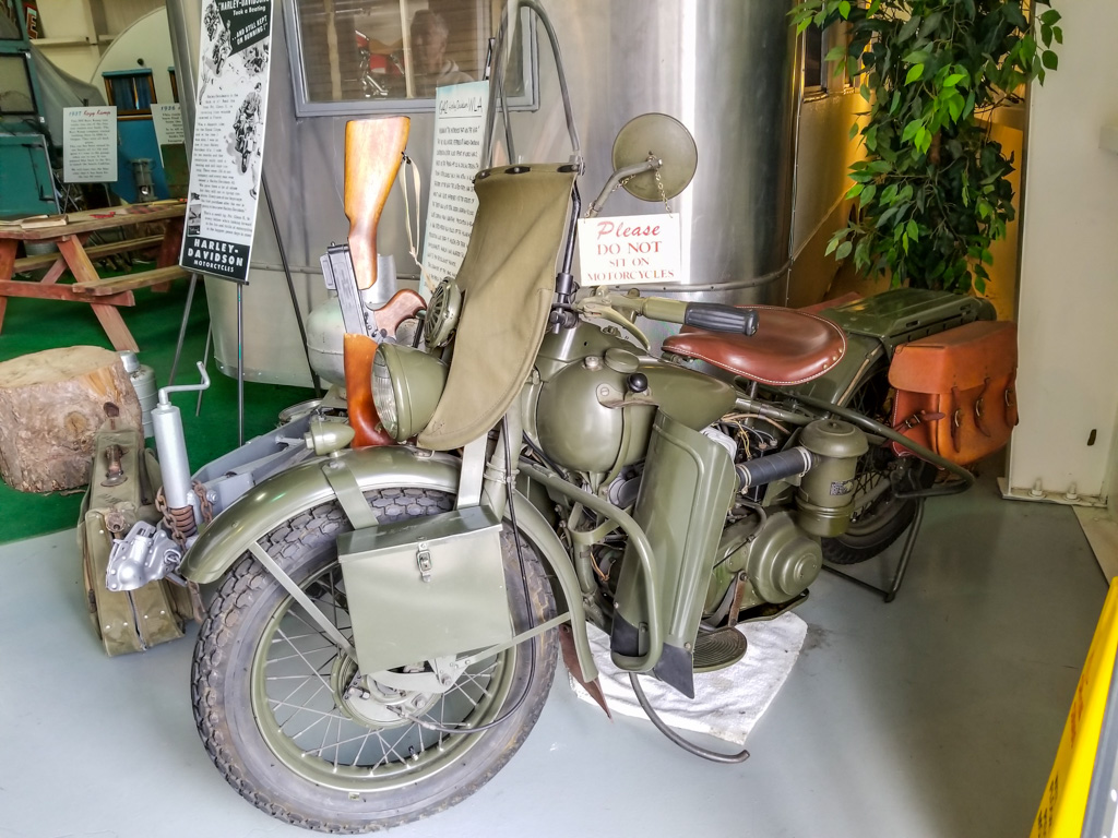
Jack is a motorcycle fan as well, and has many exhibited through the museum.  Impressive!

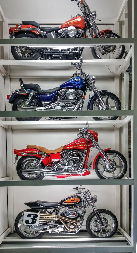
Here are two that caught my fancy.

One-half of all the known cycles of this model and year with  a left hand sidecar
The Harley WLA from WW II.  Since most of these were modified for civilian use after the war, very few remain in their wartime configuration.

Big Texan: 72 Ounces of Beef

Near our campground was the Big Texan, a restaurant, kitsch (sorry, “gift”) shop, and hotel. (The company also happened to own the campground we stayed in.)  For nearly 100 miles on I-40 as we were approaching Amarillo, we saw billboards for this restaurant advertising “FREE 72 oz. STEAK!”

The hitch, of course, is that you have to eat it all in an hour.  Not only the steak, but:

  • Shrimp appetizer
  • Salad
  • Potato, and
  • THE STEAK.

And they mean ALL of it.

This is what 72 ounces of beef looks like! Yeah.  Four and a half pounds.

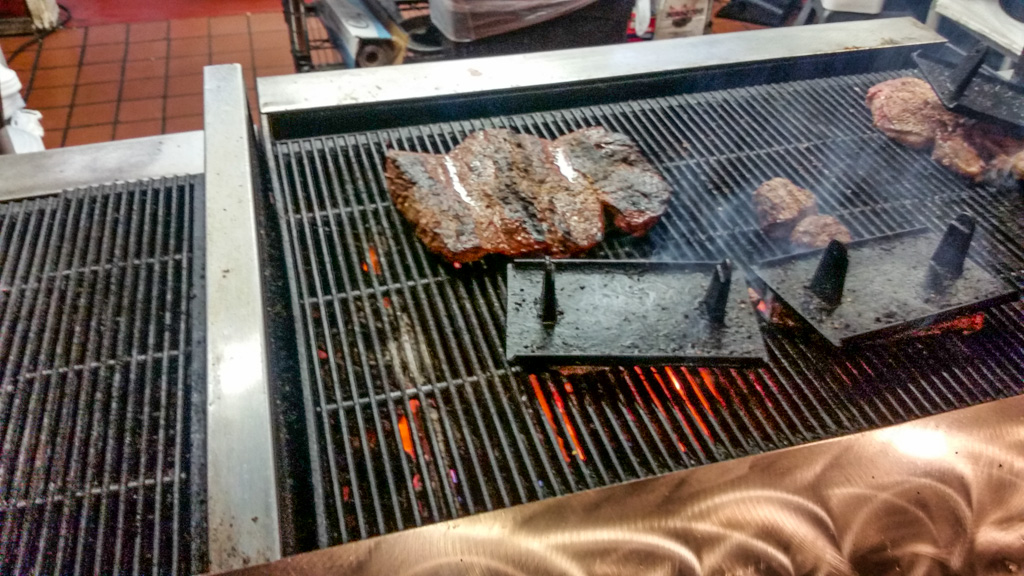
I was told that about 1 in 7 finish in under the time limit.  According to our server, you have to pay first, which is returned to the lucky few.  And you eat it on a stage, so everyone else can watch your valiant efforts!

The fastest time (according to the web) is by a small woman who finished the steak in under 3 minutes! You can find it on You Tube pretty easily, but trust me, you do not want to watch it!  It isn’t pretty.

Want to try? Neither did either of us.

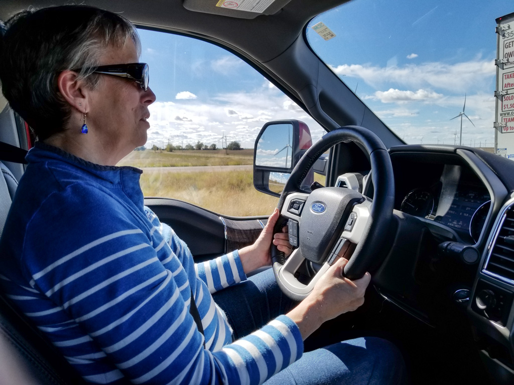
Finally, just want to note that Kathe has driven every single one of our more than 8,000 miles of this adventure!  Way to go!

Bucket list: √ and √

Go get your bucket list. I’ll wait while you go find it.

Now add these two items which are in New Mexico, if they’re not already on your list:

  1. The Very Large Array,  otherwise known as the VLA, and
  2. Bosque del Apache National Wildlife Refuge.

√ and √!  Our bucket lists are now two items shorter!

The Very Large Array

I’ve been a space fan since the late ’50s, when my dad took me out in the yard and showed me one of our first two satellites—Explorer or Vanguard—at this point I don’t remember which.  I remember watching all of the Project Mercury launches on TV with him.

I’ve known about the VLA for a long time (yes, even before the movie Contact!), but I had never been there.  Now we have!  It is even more impressive in person.

The VLA is a radio telescope, one of the most sensitive in the world.  From the National Science Foundation website:

Among a broad range of scientific capabilities, the VLA addresses four primary science themes: measuring the strength and topology of cosmic magnetic fields; imaging young stars and massive black holes in dust-enshrouded environments; following the rapid evolution of energetic phenomena; and studying the formation and evolution of stars, galaxies and active galactic nuclei.

Phew!

The VLA is open to scientists all over the world who must submit research proposals to compete for telescope time.  The proposals are reviewed for scientific worth and feasibility. It is so highly competitive that, “Even highly ranked proposals are not guaranteed to receive observing time.

The VLA is a long way from anywhere.  We approached from the east, from I-25, and it is over 50 miles away—50 miles of passing almost nothing but beautiful scenery!

Typical central New Mexico scenery (not actually on the way to VLA–where I neglected to take pics!)

Located on the Plains of San Augustin, the site is both high at approximately 8,000 feet, and ringed by mountains. The height reduces the amount of atmosphere-induced distortion of the radio waves, something I had never considered.  The mountains block most of the man-made radio interference.  Any electronic devices you may have with you like cell phones, tablets, fitness trackers, smart watches, etc. must be turned off—completely. Digital cameras are (surprisingly) OK.  Needless to say, having your cell phone off doesn’t matter as there is absolutely NO coverage!

Approaching the VLA—still a fair distance away

The 28 antennas are huge!  The dishes are 25 meters (82 feet) across, and they over 200 tons each. When pointed up, they are 90 feet to the apex. You can’t really get an idea of how big until you have something to use for scale.

Four flights of stairs and we’re not even up to the pivot!

Twenty seven are in active use; there is always one in maintenance; they rotate through all the antennas to keep them all in good condition.

The VLA has four configurations, called “A” (far Apart), “B”, “C”, and “D” (Darned close together).  The configuration is changed every four months, and we were very fortunate to visit when the telescope was in configuration D.  In configuration A, each of the three arms of the telescope is thirteen miles long, and photography wouldn’t have been nearly as much fun!

Antennas close together! The beauty of Configuration D.

The VLA is laid out in three legs radiating out from the center, spaced at 120°.

Looking out the north leg, currently comprising 11 of the 27 antennas.

To reconfigure the array, and to bring antennas in for maintenance, they use a transporter. Top speed is 5 MPH; however when transporting an antenna, it usually moves about 2 MPH.

Zero to two in… several minutes.

The reason for the different configurations is that antenna spacing controls the field of view, how wide a portion of the sky it can view, and resolution, how small a feature it can distinguish.  Close spacing (like now) offers a very wide field of view, but relatively poor resolution.  The widest spacing, configuration A, views a much smaller portion of the sky, but can distinguish much smaller features.

At its widest spacing, the telescope is about 22 miles across.  To allow even finer resolution, the VLA is one component of the VLBA, the Very Long Baseline Array, which has a maximum distance between antennas of 4971 miles (8000 km).  The VLBA is controlled from the same building as the VLA, in Socorro, New Mexico; the antennas are spread out from Hawaii to the U.S. Virgin Islands and points in between.

If you want to see the VLA, go soon.  Its replacement is currently in the works, called ngVLA, which will increase its power and its resolution at least tenfold. The individual dishes will be smaller, but there will be many, many more! More information is here, and here (FAQ).

√ The Bosque del Apache NWR

Several years ago I heard about a great place for bird photography, especially for sandhill cranes and snow geese.  It wasn’t over-hyped! In the two days we spent there, we took on the order of 3,000 pictures!

The peak of the bird population happens during the depth of the winter in December. At that point they have approximately 20,000 sandhill cranes, 50,000 snow geese, and 50,000 ducks of various species.

The refuge is heavily managed.  The staff plant several food crops during the summer to feed the birds through the winter—mostly corn.  They plan to feed 100 pounds of corn per bird across the winter.  That is a LOT of corn! They also flood fields with water from the Rio Grande river to give more shallow water areas so the birds have safe places to spend the night. When we were there,  only a few of the fields were flooded; more to come!

Even now in November, there are a phenomenal number of birds here. During the day, the birds are spread out widely across the 58,000 acres of the refuge.  Even so dispersed, the density on any of the feeding areas is pretty high!

Sandhills feeding
Snow geese soaking up the rays.

At night they congregate in a few, relatively small wet areas—being in shallow water protects them from many predators.  This congregation into a few areas results in massive “fly-ins” and “fly-outs” at sunset and sunrise. Photographic heaven!

Go ahead! Count the sandhill cranes. I dare you!
Predator spotted! Snow geese flying out.
Incoming! Sandhills arrived in groups like this continuously for over a half hour.
Three sandhills landing simultaneously.

During the second day, we took two  (free!) tours with naturalists to find other birds which were located on the Reserve. Many were too far away to get good pictures of, but here are a few of the birds we saw.

A trio of cedar waxwings – one of Kathe’s favorites!
Phainopepla, the desert black cardinal.
We think this is an American Kestrel, a small falcon.
A bald eagle, in a snag.

In addition to so many birds including quail and turkey, there are many other species of animals on the refuge including mountain lion, bobcat, jackrabbits, and lizards.

It will take us weeks to work through all of our refuge photographs! Based on this fabulous experience, we’ve decided we’d be thrilled to visit as many wildlife refuges around the country as possible. Fortunately, there are quite a few in Arizona where we will spend the winter. Yahoo!

On the moon?

Early on in our trip planning, White Sands National Monument was on our list.  But then we decided that we’d like to see some of Utah “before it got too cold,” so we planned to go west on I-40 all the way into Flagstaff and then north.  We decided that we’d do White Sands, NM some other time.

Well, “too cold” seemed to be following us all the way across the country (local temperatures were often 15° to 20° below normal—we started to think that it was our fault!).  We decided that we would drop down to a more southerly, i.e., warmer, route—I-10—after Bosque del Apache.  Yea!  White Sands was back on the route!

White Sands National Monument visitors’ center, built in the 1930s.

We knew that there are basically two “White Sands” things.  There is White Sands National Monument, and also White Sands Missile Range, the largest military base in the country in terms of area. The Missile Range is closed to the public (of course), so we focused our imaginations on the Monument, which we thought was completely separate.

It turns out, it isn’t so separate.  The Monument is completely inside the missile range; it closes to public access any time the military launches a missile. Phew!

The other thing we didn’t know was that the missile range has a museum open to the public! Did I mention in a previous post that I like space-oriented things?

White Sands Missile Range Museum

The first day, we went to the museum.  Since you’re entering a military base (by all of about 100 yards), you must present ID, and they run a quick check with the FBI to see if you’re a baddie. (Sorry, no pics of the entrance station where we had to register.  That is apparently a serious no-no.)

Outdoors display

We spent most of the time at the museum outside at the rocket display.  It was neat to actually see some of the rockets whose names I knew from the ’60s.

The Patriot, launched from a truck
Some of the missiles in the outdoor portion of the museum


The OH-50, an unmanned helicopter developed in the 1950s for anti-submarine warfare. Drones aren’t new! Although it is no longer in use in combat, it is still the only unmanned helo to be combat certified.  The OH-50 is still used at the Missile Range to tow targets.
WSMR is an Army base, but used by all branches of the military. This is a Navy guided missile launcher tested here.

The rockets on display here were almost all developed for the military, but they also enabled our manned space program.  Until the Apollo program’s use of the Saturn V booster, all of the rockets used for our manned space flights were repurposed military rockets—Redstone, Atlas, and Titan.  The Redstone held a special place in my memory because it was used for Alan Shepard’s and Gus Grissom’s sub-orbital flights at the start of Project Mercury, the beginning of the US manned space program.

I didn’t know that the Redstone was designed to be “transportable.”  From the information sign in front of the rocket:

As a field-artillery missile, Redstone was mobile and transportable by plane, truck, or train. However, when on the move, it needed a convoy  eighteen miles long, with 200 vehicles carrying approximately 10,000 individual pieces of equipment and more than 600 men.  The Redstone itself was carried on three trucks—its nose section (warhead), midsection (power plant and fuel tanks), and tail section—to be assembled in the field.

Transportable?  Maybe.  Stealthy? No way!

Indoors

There was also a nice indoor portion of the museum. Part of it covered the computing resources used in the early days of the missile age.  Here is a “patch panel” used to program a computer in the days before software.  This is from a computer used into the ’70s!

A quote on the information card: “You had to be a bit crazy to work on the patch panels!”

One way of gathering data about test flights is to track the rockets visually, with “cinetheodolites.”  Each of these required two operators, and many were used around the range.

A cinetheodolite ($75,900 on eBay!  Get yours today!)
Housing for a cinetheodolite

Trinity

There are moments that change the course of history forever; one happened here. On June 16, 1945, the world’s first atomic explosion happened on White Sands Missile Range, at the Trinity Site.  The Trinity Site is only open to visitors twice a year so we weren’t able to see it first hand, but a good portion of the museum’s indoors display space is devoted to it.

A one-third scale model of the bomb that was detonated at the Trinity Site.

The Trinity bomb was the same design as the second bomb, dropped on Nagasaki, Japan, to end World War II.

White Sands National Monument

On the second day, we went to the National Monument.  Mile after mile of white “sand,” actually gypsum.  After having seen the delicate gypsum florets in Mammoth Cave, it was amazing to see this much gypsum, literally piled up.  Kathe thought it looked like we were on the moon!

This plant’s root system causes these hills to remain even after the dune has moved on.

The leaves of this tree are thick and very waxy

It was interesting to walk on the dunes.  I have lived near the water all my life except for our time in New Hampshire, and am used to walking on sand—including the sand dunes on North Carolina’s Outer Banks.  The gypsum packs much more tightly than sand,  and is very easy to walk on in comparison.

We went sledding down the dunes on a plastic saucer (like would be used on snow).  Despite waxing the bottom of the saucer, other than the color of the dune’s surface, it wasn’t anything like sledding on snow!  It was quite sticky, but once you got going, it was fun riding down the dune.  Kathe got some good rides, but I fell out of the saucer each time! Unfortunately, I didn’t get any good video of me tumbling down the dune. (Sand-sky-sand-sky-sand-sky…)

The dunes are always moving, driven by the wind.  Keeping the tourist area road open is a constant problem.

Harder than plowing snow? I don’t know…

We had a really good day there, walking some trails and seeing the scenery.  Al finished with a ranger-led walk just before sunset.  The guide is an astronomer by training,  working as a paleo-geologist.  He described some of the research going on at the whole White Sands site, much of it outside the bounds of the Monument.

On the desert floor (where there isn’t currently a dune), the water table is only a foot or two below the surface. The geology  of the area depends on this.

A wet stick shows that there is water about 18 inches down this hole. The water table (the level of the water below the ground) is closely monitored.

The yucca plant below may be 30 or more feet tall.  It is rooted on the desert floor, and as a dune comes along it grows to keep its leaves and flowers above the level of the dune.  Unfortunately, when the dune passes, the yucca can’t support its long stem.  It collapses and dies.

You didn’t think I’d leave without a sunset shot, did you?

Blue sands at sunset

If you get a chance, do plan to go.  White Sands National Monument is other-worldly.  (Lunar?)

It’s Gettin’ Real – and We LOVE it!

Boondocking. It was a new word for me. Just over a year ago.

We had already purchased our RV — let the planning begin!

While we were dreaming about what might be ahead for us as we neared Al’s retirement,  he mentioned (with great excitement) the possibility of boondocking. It sounded like something out of a 60’s sitcom, but I soon learned what it meant.

No hook-ups. What?!?!

So, when you camp with an RV, you can camp in a campground or state park that might have hook-ups, i.e., a spigot that you can attach (with a hose) to your camper, a pedestal with electric power (30 or 50 amps) that you can connect with an electric cord to your camper, and a septic hook-up—you got it! You hook up your sewer hose to the hole in the ground. You get the idea.

In some of the campgrounds we have visited en route to Arizona, we stayed *very* close to our neighbors.  It’s not unusual, if the campground is near a tourism hot spot (a National Park, a popular city), to be lined up very close together.

Another name for boondocking is DRY camping.  It can also be called dispersed camping—as you are outside of a campground. You bring your own water, provide your own electricity (if you choose to), and have to dispose of your own waste—both black (septic) and grey (shower, kitchen sink) tanks. It’s just you and your “campsite.” And lots of room.

We knew we wanted to be in the Southwest for the winter. We’d visited Arizona several times and loved it. Less than a year ago on our last trip to Arizona (before we took delivery on the RV), we drove around to check out some boondocking sites.  I remember my stomach doing a little flip as we drove through some fairly desolate areas. I couldn’t help wondering…will I feel safe? Will I feel isolated and lonely? What if we run out of water? And on and on.

Al assured me it’s something he’s sure I could handle but there was absolutely no pressure. We took delivery of Rhett (our fifth-wheel coach) in April and had lots of fun dreaming about where we’d take him. Occasionally, Al would mention the boondocking “thing” and soon he started investigating solar power for the RV.

For those of you who know Al, you will understand when I say that he researches everything VERY comprehensively. He’s been a regular on the Grand Design Owners’ Forum  online for over a year — and has learned SO much from SO many.  As he learned more about solar and helped me to understand what it would allow us to do, we soon decided to get a recommendation for an installer.

Al already told you all about that install in an earlier post.

So, here we are now. On the desert. So what’s it like? Here are the good points:

It’s dry, dry, dry.  (NO snow!)

There is lots of sunshine, but it never gets too hot. We’ve been averaging in the mid-to-high 60’s and sitting out in the sun is a pleasure. The nights are cool and we sleep with a bedroom window open. Love it.

We have been able to run everything from our eight solar panels, and haven’t run the generators yet. It’s going to be quite overcast for the next couple of days (it’s actually raining right now) so we may end up turning on the generators to keep our batteries topped off.

We have plenty of water and if we need to refill, we either drive the RV just 2/10 of a mile to fill up OR Al puts the large water bladder into the truck bed and takes it to fill.

We have a good deal of space to ourselves;  Here, we’ve got several acres of desert to ourselves. It’s nice! And, as you can see, Al can fly the drone here—he’s quite happy about that.

The sunrises and sunsets have been absolutely glorious! (If you follow me on FB, you’ve probably seen my photos — it’s so hard not to share them!)

    A magnificent sunrise—I took this pic from bed!
Sunset on the desert.

There is lots of space to ride our bikes (although some of it is a bit, um…challenging! More about that below).

The surrounding scenery is magnificent. There is so much to explore—a number of huge wildlife refuges included—yeah!

I’m sewing again—and I seem to have my cooking mojo back, too.

Sewing again!

Black bean enchiladas with Hatch chiles. Yum!

And the not-so-good stuff:

Wi-fi has been spotty at best when camping. Luckily, my Messenger and Words with Friends games don’t use much data so I’ve been able to keep up with folks. I’ve even been able to still participate in my Maine church’s Bible Study via Facebook video. And email works, too, but on its own schedule.  But forget it if you want to use the Internet—downloading or even just following a link is impossible 90% of the time. (I know—first world problem!). We’re in the public library right now because they are hard-wired for the Internet—it’s like buttah! (And this is a pretty amazing library for such a small town—we need to find out about library cards for snowbirds.)

DUST…DUST…and you guessed it, MORE DUST! I know—we choose the desert.

Biking off-road on the desert can be a bit tricky.  I took another spill off my bike this week. When you’re trying to cross the desert (think: bushwacking), you never know when you’re going to hit a patch of deep sand or rocks, and those desert washes can be a challenge!

Off we go! Pretty innocuous.  We’re actually on a four-wheeler track here. It’s all fun and games until you decide to  cross the wash (it’s where the water collects when there’s rain—and therefore, it’s quite thick with bushes and undergrowth—and steep gulleys). Like this…

I’ve been kinda lonely.   Don’t get me wrong; Al is great company! But I am missing my family and friends and this week, the desert grey-brown got to me.  It didn’t feel like Advent at all. And being together 24/7…well, we all need some independent time occasionally. So Al encouraged me to take the truck and go off for the day. It was *just* what I needed! I drove 80 miles south to Yuma (just shy of the Mexican border) and it was wonderful. Flowers, large trees, lush green fields of all kinds of crops, beautiful mountains, and a huge shopping area that went on forever. It was great to see lots of Christmas decorations and it really put me more in the mood.  And it was simply nice to be around lots of people. It’s a balance.

So, it’s official. We are BOONDOCKERS. And SNOWBIRDS. We’re learning how to live on the desert — and for the most part, it’s awesome!

And from a different point of view…

Now that we’re pretty much settled, we have time to play with toys (repeat after me: “Toys are good!”) and take day trips.

Not too far from here are the Blythe Intaglios.  If you don’t want to click the link, briefly these large desert drawings were created by early indigenous people by scraping aside the dark stone layer at the top of the desert floor, exposing the lighter colored earth below. Also called geoglyphs, these are very hard to date.  However scientists believe they appear to be between 2000 and 500 years old.

They’re very hard to see from ground level, so our drone whispered in my ear…

#1. Considered the best preserved of the intaglios, this human figure is 105′ from head to feet.
#2. Depiction of a man, 102′ from head to feet. The line across the knees is part of what was originally a circle; only the part inside the fence is still easily visible. If the figures were sacred, is it possible the circle is the remnant of a dance ritual?

The intaglios were first “discovered” by modern man in 1932 by a pilot flying from Las Vegas to Blythe (CA).  The intaglios were fenced in in 1974, after it became clear that off-road vehicles would destroy them.  There are visible tire tracks in both pictures above. There are several theories about their original purpose and of course what set of theories wouldn’t be complete without one or more about aliens!

We are constantly in awe of the scenery here.  I know that the desert landscapes don’t appeal to everyone, but they really strike a chord in me.  See if you can spot the Colorado River.

We’ll go back in the new year (we’ll be camping in another location closer to them), to try to find the remainder of the intaglios.

Back at the ranch (OK, camper), I’m enjoying getting familiar with the drone, and with video editing at which I am a COMPLETE newcomer.  Here is a quick view of our current location.  We are in the camper near the bottom, just to the left of center.

At some point I’ll post a video with audio, or with multiple scenes composited. I’m not good enough at that yet!

Hope you have a great day!