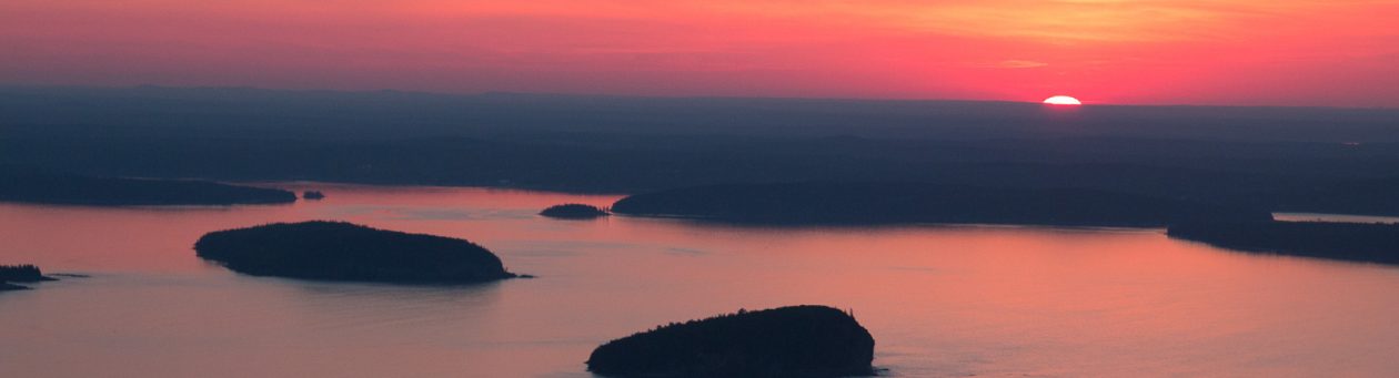
On day 21 we moved to Salt Lake City. Tomorrow we are flying back to New York. But, today we also went to the Loveland Living Aquarium. It was so cool and interesting. Some of my favorite animals are Macaws, and Sea Turtles and there was actually a Macaw there! Even though it’s mostly an Aquarium, there were still animals that don’t live in the water. And there were multiple Sea Turtles.
The biggest tank was the shark tank. But, it also had fish and rays in it. One of the coolest animals that I saw that I didn’t know about before was the Giant Shovel Nosed Ray. But, it was super fast and we were trying to figure out what it was that we weren’t able to get a picture of it. But feel free to look it up.
Again, again we’re sorry that we’re behind. But our next adventure awaits!
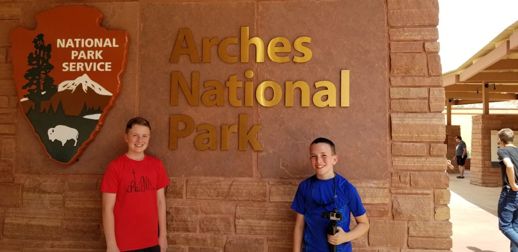
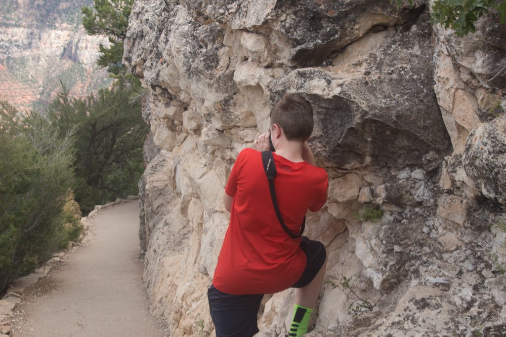
On day 15 we went to Arches. We headed into the visitor center to learn about the park and watch the video about the park. It was really hot that day, over 100 degrees. Since it was so hot we stayed in the truck most of the time, and stopped at points to take pictures.
We planned to go to Delicate Arch, but in the end we decided not to go because the trail up was steep and it was really hot. But we got pictures of Delicate from the bottom of the trail.
And if you were here when Dean and Graham did this trip, you might remember the sushi boat. Well, on day 15 we went and got the sushi boat for lunch! It was so delicious, that we had to tell Brynn to slow down so we could all enjoy it. Brynn absolutely loves sushi and was so excited to have sushi!
Day 16
Written by Brynn
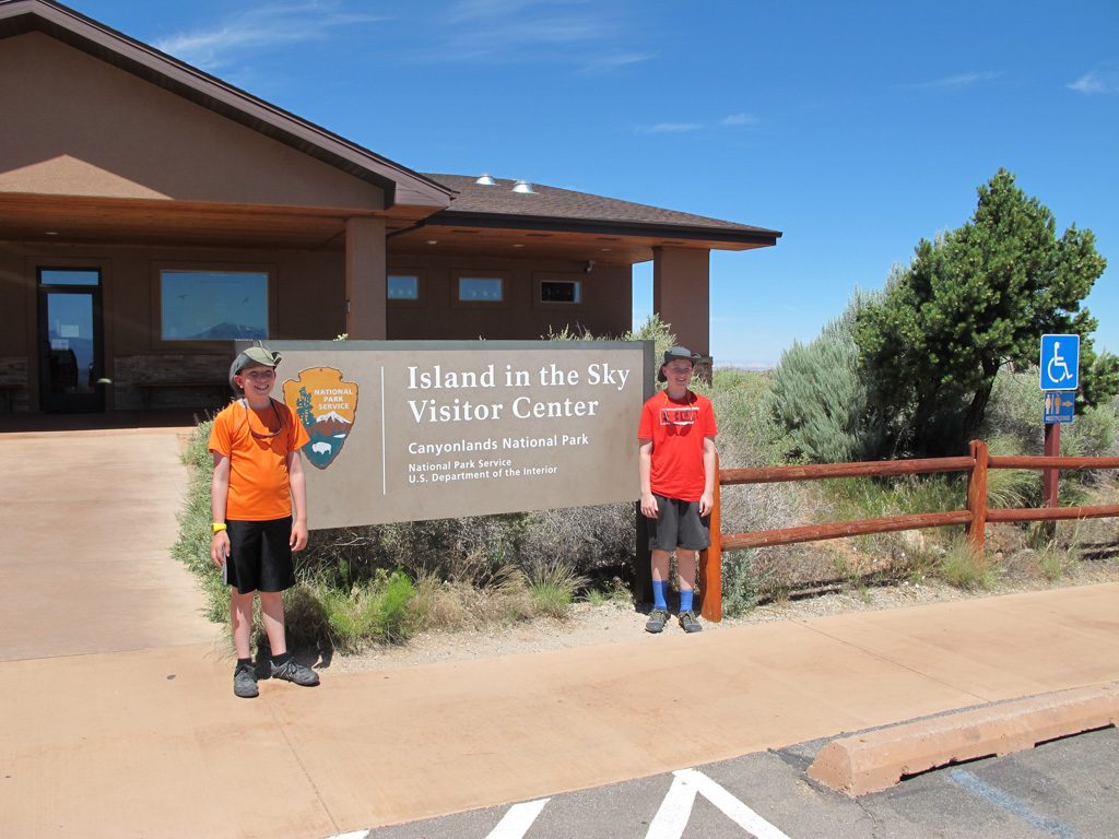
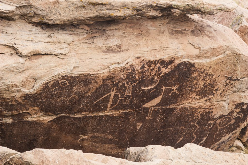
Day 16 was when we went to Canyonlands! We drove over a bunch of cattle grates on the way to Newspaper Rock. They were very bumpy! Newspaper Rock had a bunch of petroglyphs! There were different but also similar to the Capitol Reef petroglyphs. Some petroglyphs that we saw were a mommy and a baby’s footprints, more pronghorn, and people! They were great!
Next, we went to the Visitor Center. They had displays of the different kinds of rocks of the Canyonlands! I thought it was really cool! They all had different colors and were made at different times! We had lunch outside of the Visitor Center which was pretty nice! Then, we drove a little bit more into the park and went to some viewing spots. They were very pretty! At one spot, there were different rock formations that looked like animals. After that, we decided to head back to camper.
Grandma & Grandpa surprised us by getting Fro-Yo! Once again, the Strawberry was out! It doesn’t make sense! I got mango again. But this time, I got it with strawberries, blueberries and crushed up Oreos. It was really good! Soggy Oreos? Who cares?! Not me!
Day 17
Written by Mira
On day 17 it was another travel day. Our longest drive of the trip! It was 5 hours, but we took breaks to have lunch, and stuff like that.
Once we got to the campground, Brynn found out that there was a pool and immediately wanted to go swimming. (She’s a fish) And Grandma and I played a game while Grandpa and Brynn were at the pool.
Day 18
Written by Brynn
Day 18 was super cool! The whole reason we stayed at the campground was because that it was very close to Dinosaur National Monument. The drive was not that long, and on the way, we saw that the town had lots of dinosaurs everywhere. First, we stopped at the Visitor Center to see all the displays and get on a shuttle to go to the Dinosaur Quarry! I was so excited to see all of the very old bones! When we entered, I learned that most of them were millions and even BILLIONS of years old! I’ve never seen anything like them in real life! They’re so incredible! I definitely recommend traveling there!
Day 19
Written by Mira
Day 19 was yet another travel day! On the way to the next campground we stopped at Flaming Gorge, more specifically the Flaming Gorge Dam. We explored the visitor center first, then we went outside on a platform to look down on the dam. We had binoculars with us so we were able to look at some fish that we saw hanging out at the base of the dam. Then we went to a restaurant for lunch, Brynn had a sandwich and I had chicken. Then we got back on the road to get to the campground which was actually in Wyoming! But to get there we had to drive across the dam.
FUN FACT: If you take the Empire State Building and lay it horizontal and curve it against the dam, the top of the dam is the same length as the Empire State Building!
Day 20
Written by Brynn
Day 20 was a very relaxing day. We only went to the pool to swim, (I was the only one who swam) went to a restaurant for lunch and went to the pool AGAIN! We also came across this man with a VERY famous owl. His name was Hoot. Apparently, he was in Harry Potter! THE MOVIES! I was astonished! Then, we went back to the camper and played the game Quacks of Quedlinburg. Mira won. She’s the queen. Overall, it was a very calm day.
Again, we’re sorry that we are behind with posting. But we look forward to sharing our next adventure with you!
We packed up and moved to Moab from Capitol Reef. But on the way we stopped at Goblin Valley State Park. Goblin Valley was really cool because we actually got to go down into the area where the “Goblins” are. And we got to climb on them! It was very hot though so we made sure to take a lot of breaks for water and just to sit in the shade.
Written by Brynn
The “Goblins” were actually just rocks. But they’re called Goblins. To me though, they looked like either mushrooms or gnomes. They were very fun to climb on, and to see from on top of them! There were lots of different formations to see. It has been our most active adventure so far! Once we got back on the road, I couldn’t stop thinking how fun it was!
Finally, we got to Moab and our campground. We didn’t want to go into the national park, because it was very hot outside. It was 107! So we decided to play a game called Canvas. It’s very fun! Then after, Grandma & Grandpa suggested going to get Frozen Yogurt! Mira & I have never had it! Grandma & Grandpa were surprised! So, we went to get it. Out of the flavors, I really wanted strawberry! But it was out of order! I was disappointed. Instead, I got Mango with little pieces of Mango and Strawberries on top! It was delicious! But guess what… then they took off the sign for the Strawberry! It was working right after I started eating! Such a coincidence!
We’re sorry that we’re behind on posting! But, we look forward to sharing our next adventure with you!
On day 12 we packed up the camper and moved to just outside Capitol Reef. Once we set up the camper we ate lunch and headed into the park. We went to the visitor center to learn about the park. We learned that it’s named Capitol Reef because there is a rock formation that looks like the Capitol.
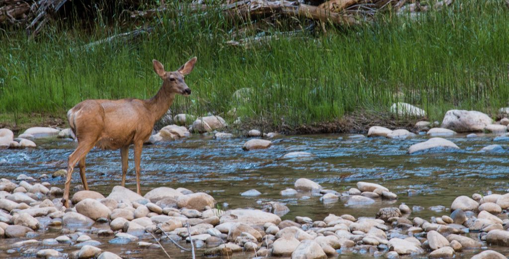
We also went to a little park area where a few deer were hanging out. There were three total, two females and one male. The buck had antlers and the antlers still had the velvet on them. Which means the antlers were fuzzy.
Day 13
Written by Brynn
Day 13 was sort of busy in the morning. First, we went to do 2 very short hikes. It was already heating up, so we tried to do them quickly. They were super easy. The views were very pretty and cool, also!
Then, we went to a super old schoolhouse. It was so small! I bet it could fit only about 11 or 12 people. It was also very dusty inside.
Next, we went to see a wall of petroglyphs. Mira and I saw a bunch of pronghorns carved into the wall. There were also a lot of people, too. That was the most that we have seen so far!
Finally, we were about to go back to the camper, but then we saw a “U-Pick” sign for an orchard! We were trying to find one yesterday, but the fence was locked. The orchard was an Apricot orchard! Mira and I were super excited because we LOVE Apricots! There we also 2 deer! We made sure to stay far away though! Mira said that she saw a tree FULL of Apricots! So we went over and picked at least 30 Apricots! We went to go pay for them and went back to the camper. The Apricots were amazing! Definitely recommend!
Written by Mira
That night Grandpa and I went to an area in the park for some night photography. There were no people around us so, unlike last time we went to do some night photography. (When we first went for night photography in Bryce) I actually got to use the camera to take pictures for myself, instead of showing people how to take pictures of the Milky Way on their phones.
We look forward to sharing our adventures with you!
Yet another travel day! We left Page to go to Bryce Canyon City. It was a bit of a drive, but we made it! When we got there, the campground was so big! Biggest I’ve ever seen! And our site was way bigger than we needed it to be! As soon as we got unpacked, we had lunch and got ready to go into the park. As soon as we entered it, we went to the Visitor Center. It was very cool! Lots of displays! Then we rode a shuttle to our 1st viewing point. Mira and I weren’t ready! We were amazed! The park is mostly a bunch of structures called hoodoos! They are made from weathering, mostly ice and rain. Well, it has several stages. 1st, a thing called “Frost Wedging”. Some water seeps into cracks in the rock walls, and freezes. It then breaks apart the rock and creates a what called “a window”. Next, as the windows expand, the tops eventually fall off, leaving a column. Finally, erosion continue to sculpt the columns into spires, known as “Hoodoos“. It was really funny to see the hoodoos because sometimes, you would say that they were a character, or formation from something!
Then, we went out for dinner and a show at Ebeneezer’s Barn & Grill. The show was a Blue Grass show, which Mira and I had never heard of! I was really excited because I like trying new things! The dinner was really big and delicious! At first, when I heard the word “ Blue Grass,” I thought it was Country! Well, I was only half wrong. Some of it is actually Country, Blues, Jazz, Pop, and Old-time music. The show was really fun and cool! The singers were a couple and their friend. While the show was happening, 2 of the couple’s kids came out to sing with them. It was so cute! They were really good!
(Click on a picture to see it bigger.)
Day 10
Written by Mira
On day 10 we spent more time in Bryce. Grandpa took Brynn and me on the Navajo trail loop which starts at Sunset point, which we will come back to. Anyway, the trail was really fun, we started early before it got too hot. I don’t think I’ve ever started a hike by going down and end by going up! It was really pretty, with all the oranges and reds. There were a lot of switchbacks going up and down. They were steep so while going up we had to take a lot of breaks.
Once we finished, we got back to the camper, and Grandma wanted to take us to the general store. Brynn and I were looking for earrings and we found some! Brynn got dragonflies and I got whales, Brynn also got an amethyst geode and I got some magnets to fidget with.
If there is one thing you should know about me, it’s that I absolutely love looking at the sky and stars. I just think it’s so magical and majestic! Anyway Grandpa and I went back to Sunset Point at about 8:30 (Utah time) and we waited for all the stars to come out. We saw the ISS and the Milky Way! There were a quite a few people who were there that all wanted to take pictures of the Milky Way with their phones. So I was teaching people how to take a long exposure pictures. Which if you don’t know it opens the camera for a longer period of time, which lets more star light in. Making a better picture! I guess that’s what happens when you take the daughter of a photography teacher for night photography!
Day 11
Written by Brynn
Day 11 was our last day in Bryce. It was a very relaxing day. We didn’t do much other than going on a scenic drive through a little bit of the park. There were about 8 points to view, and we went to all of them. Some of them were Farview Point, Ponderosa Point, Agua Canyon, and Natural Bridge. On the way to all of those, we found out that on June 14th, 2009, a lightning strike started a fire that burned 3,947 acres in Bryce Canyon National Park. We were very surprised that it happened so long ago because there wasn’t a lot of growth in the trees. All of the view points had great views of the park! I definitely recommend going to Bryce!
We really look forward to sharing our new adventures with you!
On day 8, Grandpa took Brynn and me to Lower Antelope Canyon. Grandpa has been to Upper Antelope Canyon. We went on a tour of the canyon, and we actually got to walk through the canyon. It was super cool to see how it was carved out by water unlike the sandstone above which was eroded by wind. The shapes were much more jagged above, but inside the canyon since it was eroded by water it was completely smooth.
Written by Brynn Simons
Our tour guide was really nice and would show us all the different shapes in the rock. Or the shapes caused by the rock outlining shapes and the shapes would be the sky. Some of my favorite formations in the canyon were “The Woman in the Wind,” “Rocky Mountain Sunset,” and a cute little heart! We took lots of pictures, obviously because there were so many sights to see! I really hope that I will get to come back here! It’s one of my favorites so far!
We can’t wait to share more of our adventures with you!
Day 6 was yet another traveling day. We went from Grand Canyon Village to Page, Arizona. Along the way, we stopped at a big Navajo trading post for lunch. We looked around the store for quite a while before we got hungry for lunch. The restaurant’s most famous dish was recommended by Dean and Graham, our brothers. They said that the famous “Navajo Taco” was really good and that we should try it. So we all got Navajo Tacos (and I got mine without tomatoes because I don’t like them – they’re disgusting!) —they were delicious! None of us finished the meal and so we got containers to carry them home in the RV fridge.
After that, we continued on the road until we saw another really small trading post with just one person. All of her jewelry was handmade and all of us were really impressed because they were all so pretty. Mira and I were going to buy something, but we decided that this wasn’t the place, so we continued on the road again. Finally, we got to Page.
Our campsite was literally right next to the indoor pool. I was really excited because I love swimming. When Mira and I went into the pool with Grandpa, we realized that the pool was kinda nice! The hot tub was good, also!
Written by Mira
The 4th of July (Day 7) was a busy day! First, we decided we would go to visit Horseshoe Bend. It was a bit of a walk from the parking lot. Grandma and Grandpa said it was way different from when they’d been there several years ago. Horseshoe Bend is basically a formation of rock that’s really big in the middle of the Colorado River. We saw kayakers and a speed boat—they looked like tiny ants!
After that, we went to the Glen Canyon Dam Visitor Center. The Glen Canyon Dam was built on the Colorado River, the dam caused Lake Powell. Lake Powell is about 254.1 mi2 big. It was really interesting looking down on to the dam from the visitor center. We went to a Ranger Talk, and the ranger told us that in May of 1983 plywood had to be attached vertically to the top of the dam so that the dam didn’t overflow. The plywood was eventually replaced with sheets of metal. Once the Lake was down to a safe level, they were able to check and close the flood gates. What they saw was not good, there was a giant problem. In the tunnels there was a gap almost 30 feet deep and 40 feet wide. They had just enough time to fix these holes because they were afraid that they would have to open the flood gates again. But in the end they didn’t have to open the gates. And they haven’t had to open them since.
We are super excited to share more of the trip with you!
On Sunday morning, we went out to MartAnne’s for breakfast in Flagstaff. They are a Mexican restaurant and we went there because it is Grandma and Grandpa’s favorite breakfast restaurant. Their most famous breakfast dish is the “BBB”–which includes two pancakes made with buckwheat, banana, and blueberries. Mira got the BBB and I got french toast (4 pcs!) with strawberries. We surprisingly both finished our meals!
Grandpa took us to Walnut Canyon where there are a bunch of ancient cave dwellings in the cliffs. Native Americans lived there years ago. We walked the Island Trail. I’m amazed at how they were built so many years ago and are still standing to this day!
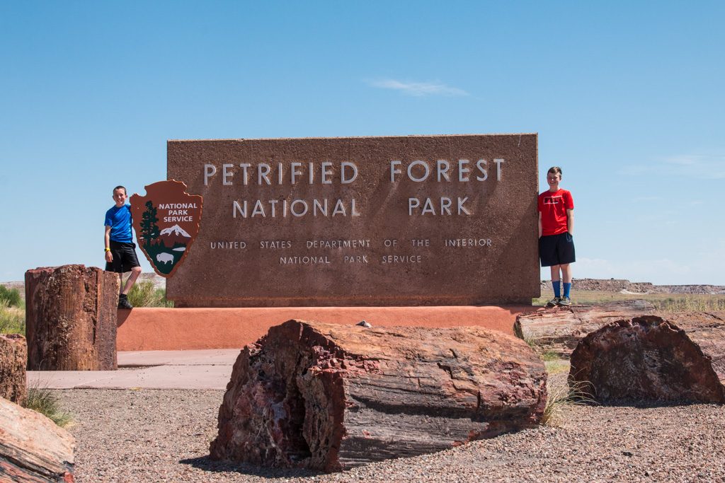
Next, we went to the Petrified Forest and the Painted Desert. At first, we took a trail into the Petrified Forest behind the visitor center. We walked part of it and it started thundering and lightning. So we went back to the truck to have lunch and wait for the storm to pass. We then tried to go back into the forest to finish the trails that we didn’t complete. We didn’t think the storm would come to us and rain down on us, but we jinxed ourselves! It started pouring down rain and it was very windy. Our hats almost blew off! While it was still pouring down rain, we decided to go to the Rainbow Forest Visitors Center and check that out and to get stickers for our water bottles.
We went to specific sites to see the different designs and patterns of the desert. There was also some Petrified Wood there. We went to Crystal Forest briefly because it was still raining. We saw lots of lightning!
We went to see Newspaper Rock — it was very cool to see all the petroglyphs. They are basically little drawings that each mean something different to the Native Americans who lived there. We saw some that represented migration, different animals, and people. A person at Newspaper Rock told us there were other petroglyphs at The Pueblo. So we went there, too.
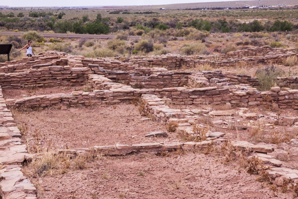
At The Pueblo, we walked on a little trail to see the ruins and some more petroglyphs. The ruins were the foundations of buildings in a small Native American village. They were short and the rooms were about the size of a king-sized bed.
From there, we moved on to see the Painted Desert. Grandpa said he had never seen it this beautiful before.
Grand Canyon National Park
Written by Mira Simons
On day four we packed up the camper and drove to just outside Grand Canyon National Park! We unpacked the camper and went into the park. This was my first time going to the Grand Canyon, and it was absolutely incredible. If someone you know is going to the Grand Canyon, don’t even try to explain just how crazy it is. Looking down into the Canyon is mind blowing. Grandma and Grandpa tried to explain just how crazy it was, but how I was imagining the Canyon was WAY different than it actually was. I thought it was going to be smaller than it actually was.
Written by Brynn Simons
I actually thought the Canyon would not be so deep! I mean, I’ve seen pictures of it, but it was absolutely astonishing! It was an awesome experience and one of my favorites! Other than that, the one thing that also surprised me was that the water was really BROWN! I thought it would be blue or green because those are the usual water colors. But I found out that there are little miniature rivers that run into the Canyon. Then they bring their own dirt and dust into the Colorado and make it brown. Those are called tributaries. It makes a lot of sense now! I’m really glad that we went to the Canyon!
Day 4
Written by Mira Simons
We spent the rest of day four at the Grand Canyon. It was very fun, but quite tiring. We made sure to drink enough water and eat enough. Once we got back to the camper, Brynn and I were crazy, Grandma said that we were overtired and I agree.
Day 5
Written by Brynn Simons
We were also at the Grand Canyon today! It was our last day in the town! We woke up a little early to get into the park before there was traffic and before it got too hot. Throughout the day we were walking and taking pictures at the places that we didn’t get to yesterday. While we were doing that, we saw and came close to Squirrels, Ravens, little Lizards, Elk and even Big Horned Sheep! Overall, going to the Grand Canyon was a great choice! I loved it!
P.S. – All pictures were taken by Mira or Brynn, except the pictures that have Brynn and Mira in them.
We look forward to sharing more of our adventures with you!
Hello everybody! We’re back in the RV for V2.0 of the trip Dean and Graham did with Grandma and Grandpa. But this time it’s me, (Mira) and my sister, Brynn. I’m 13 and Brynn is 11.
Days One & Two-June 28-29
Day one: We drove from Corning, NY to Rochester, NY. Then we flew to JFK from ROC, then from JFK to PHX.
We left Corning at 1 PM Eastern Time and got to ROC at about 3 PM. We had an amazing dinner at ROC of BLT’s and chicken sandwiches. We boarded the first plane at 6:25 and landed at about 7:20 then we had to hurry to our next flight which was very far away, we reached the gate just as boarding started. Phew! We landed in PHX at 3:00 AM (Eastern Time) which was really a little after Midnight in Phoenix. Then, after getting our luggage we had to wait for the hotel shuttle, and by the time we got to our room it was 1AM in Phoenix. Which really felt like 4AM because our bodies were still used to Eastern Time.
Day Two: We had breakfast at the hotel which was AMAZING. Then we took the truck, which was parked at the hotel before Grandma and Grandpa flew to Corning to see Graham graduate High School. (Congratulations to him!) Anyway we left Phoenix behind to drive to Flagstaff. On the way there we got stuck in an hour of traffic. Finally we got to the first of many campgrounds. The RV was left in a campground that Grandma and Grandpa had previously stayed at on the way down from Montana. Anyway we got the camper set up and went on an adventure to Sunset Crater.
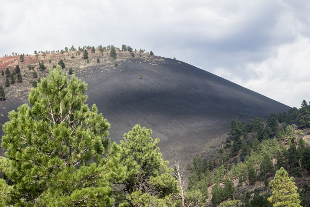
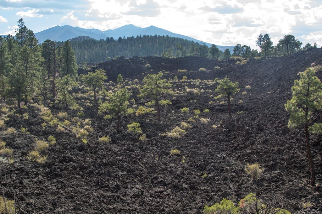
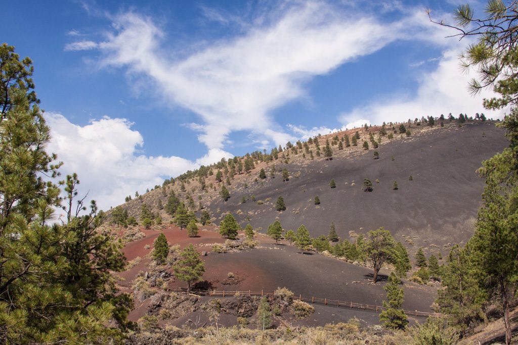
Sunset Crater is a NON-ACTIVE volcano. That in Volcano Terms, erupted recently as in 1,000 years ago. It was really interesting because the reason it’s called Sunset Crater is because the top of the cone is covered in oxidized red splatter.
Hey, I’m Brynn, Mira’s sister. The second part of visiting Sunset Crater was exploring the short little trails. There were lots of lava rocks broken down EVERYWHERE! Of course we took our cameras, because there was lots of things to take photos of! We saw some very interesting things. Some include: A very big and crooked tree, a plant called Apache Plumes, and different types of Lava Rocks and how they’re formed.
Around the Visitor Center, there were a lot of burnt trees. We found out that the reason happened on April 19th, 2022. A wind driven wild fire called the Tunnel Fire came in and burned 61% of the monument. It grew to almost 20,000 acres in 48 hours. Most of the trees were black and some were even completely burned.
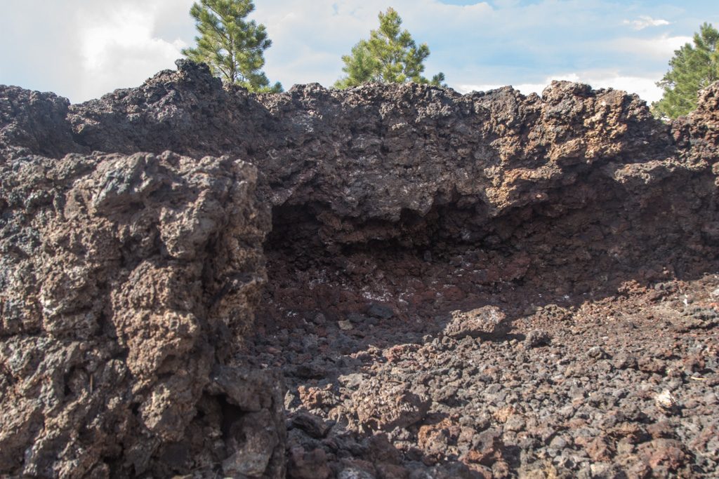
The second adventure of our day was hiking\climbing the A’a Lava Trail. Basically, you get to climb on cooled lava rocks. They were really big and jagged. It was super fun and awesome! We saw a bunch of geckos and lizards. They were always scurrying around and on top of the rocks. We had lots of fun on our first 2 days!
We look forward to sharing the rest of our trip with you!
When we started shopping seriously for an RV and a tow vehicle, we knew we wanted something that could accommodate a couple of our grandchildren traveling with us at a time. We chose an RV with a pull-out sofa bed AND a truck with a crew cab and plenty of legroom for growing kids. Even before purchasing Rhett (RV) and Scarlett (our ruby red F350), we started dreaming about when we might be able to have our two oldest grandsons join us for an extended vacation.
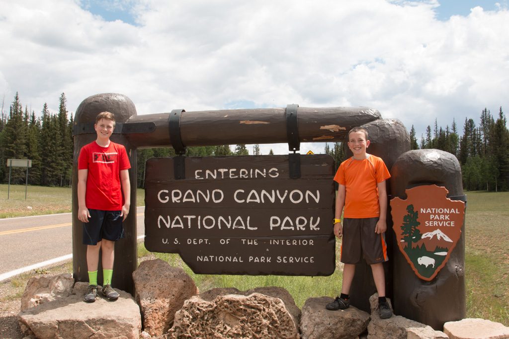
We began planning with Graham and Dean more than a year and a half ago and asked them what national parks they’d like to visit. We knew it would be summer of 2019 and by then they’d be 13-1/2 and 11. They first mentioned wanting to see Arches and Canyonland; we put our heads together and planned an amazing itinerary that would include all of the national parks in Utah as well as the North Rim of the Grand Canyon and maybe even the Petrified Forest NP.
Our first park together, Arches NP.
At Christmastime, we enlisted the boys’ help to research each of the parks in Utah—what specific places/hikes within the parks would they like to try? We chose dates and we started making reservations at campgrounds along the way — people warned us over and over about how blistering hot it would be in the summer so we made sure that we’d have full hook-ups (and air conditioning) at every stop.
Canyonlands! Park #2.
To say that these last three weeks have been everything we hoped for would be a tremendous understatement. Graham and Dean have been the most wonderful traveling companions—incredibly helpful, appreciative, curious, flexible, and hilarious! We have had such a fabulous time laughing and living together—we are REALLY going to miss them!
The most recent blog post (authored by Dean) covered our adventures through July 9th. After that, we spent time in Zion National Park, the north rim of the Grand Canyon, and the Petrified Forest NP (including the Painted Desert). The boys visited Walnut Canyon National Monument with Grandpa on the last day of our adventure.
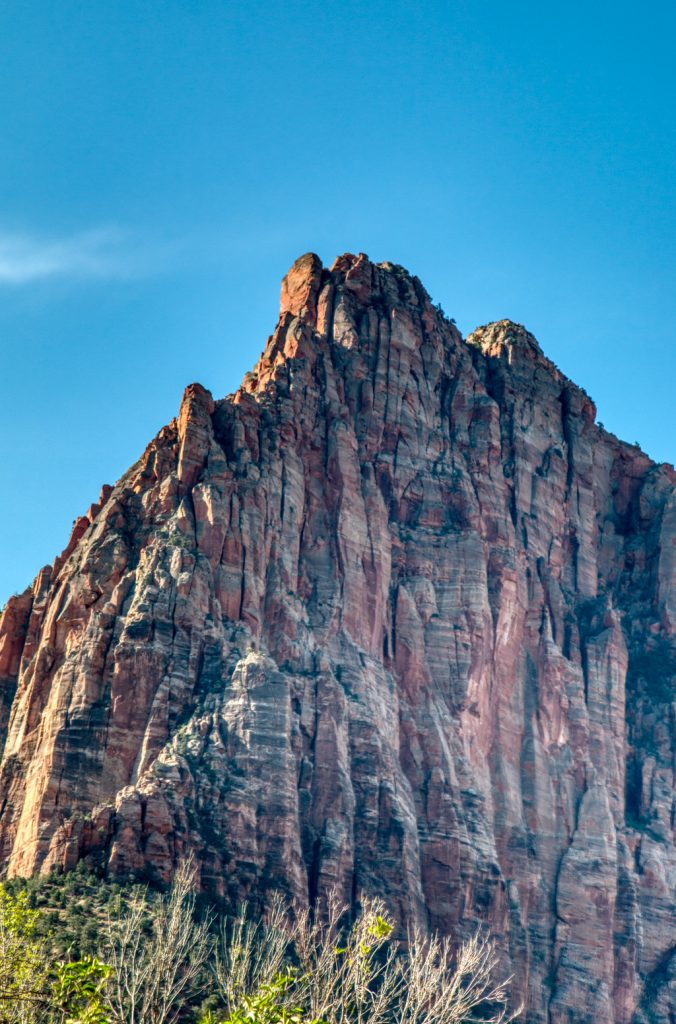
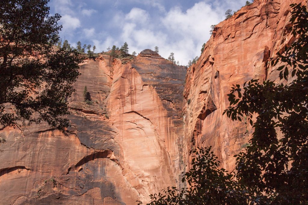
Al was really excited that we’d be able to spend time at Zion; we had visited it VERY briefly 30 years ago (when our kids were 11 and 7) and Al had really looked forward to returning for a more complete visit.
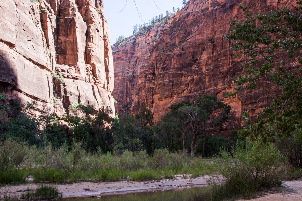
In Zion, you’re at the bottom of the canyon, looking up. A nice change!
In contrast to Bryce, Zion was incredibly warm. We topped out at 111 degrees! Our campground was about 14 miles from the entrance to the park. We were able to drive into the community of Springdale where we picked up a free shuttle into the park and transferred onto a free park shuttle. When there are shuttles running, no private cars are allowed into most areas of the park.
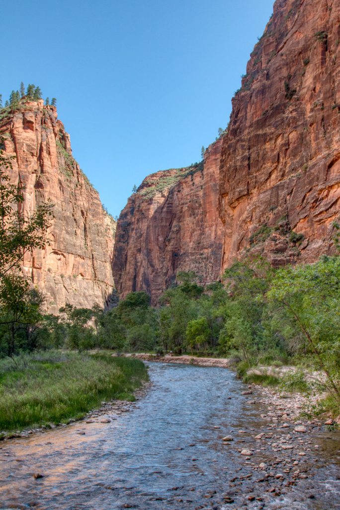
We got up early in the morning (before the heat of day) to hike the Riverside Walk up to the start of the Narrows. The shuttles were pretty busy(*) and we noticed many folks with special waterproof shoes and walking sticks. These items are available for rent for the brave souls who would actually walk up through the water-filled canyon–we talked to a couple of women who had walked in to where the water was up to their waist. One of them tripped and fell into the water (but luckily didn’t damage her expensive camera).
(*) Pro tip: The shuttles are very busy with 45 minute to one hour waits at the visitor center even as early as 7:00 AM. If you arrive at the park relatively early, drive up to the first stop, the Museum, and board the shuttle there. You’ll have to stand, but you can get on with no line! I don’t know when the museum parking fills, but there was lots of space there when we went by at a bit past 8:00.
We only went to up to the point where the trail moves into the riverbed. Maybe another time we’ll go up the river a bend or two but even going only this far the canyon shows many different faces.
Photo credit: Graham SimonsPhoto credit: Graham Simons
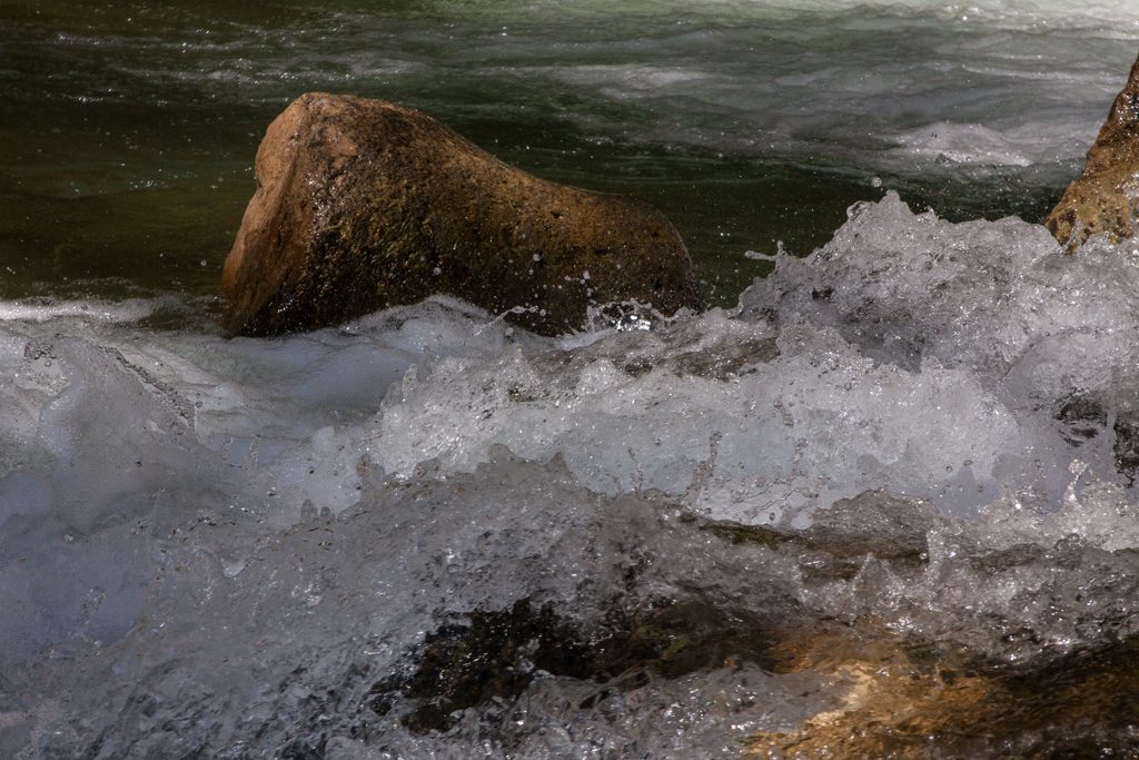
Walking alongside the river was a great time to learn about fast shutter speed photography, to stop the motion of the water!
Photo credit: Graham Simons
The land is home for the wildlife; we are just visitors.
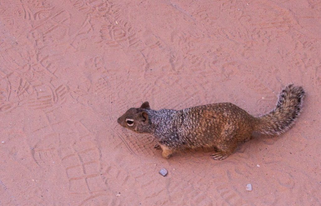
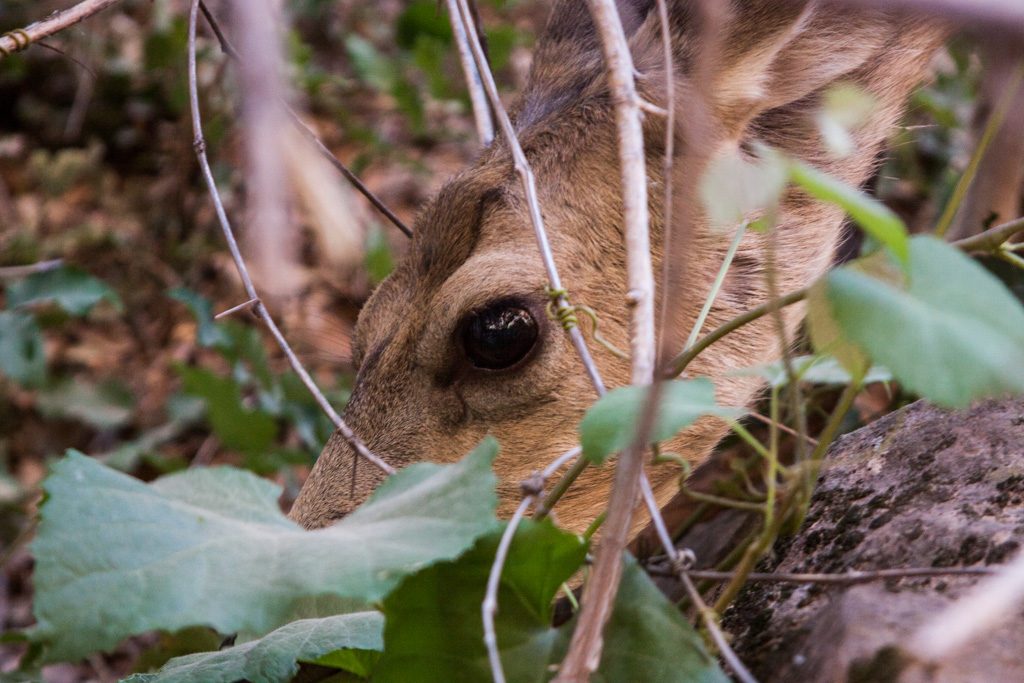
Soooo many squirrels gathering and burying food! We were walking through their pantry. Photo credit: Graham SimonsA mule deer browsing just a few feet off the trail. Is it good that they are completely accustomed to the flow of people? Photo credit: Graham SimonsBut this one wanted to get away from all of us… and did!
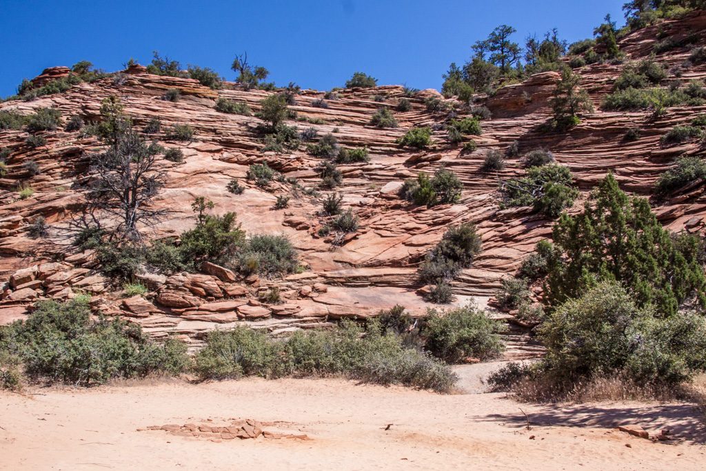
The valley section containing the canyon and Narrows is in the west side of the park. Our second day in the park, the boys and Al went to the east side, where the geography is very different.
Al: To go between east and west one must go through a long, narrow, twisty tunnel. Our dually pickup Scarlet was too large to go through with traffic flowing both directions, so we had to wait for westbound traffic to be shut down so that we (and many others) could go east. The Ranger’s last words to us before we entered: “Drive in the middle.” Talk about “it goes without saying!”
We saw so many large vehicles waiting in line both directions that I think it likely the tunnel never sees two-way traffic during the summer. But even so, we couldn’t take Rhett through if we wanted to (we didn’t), because it is too tall!
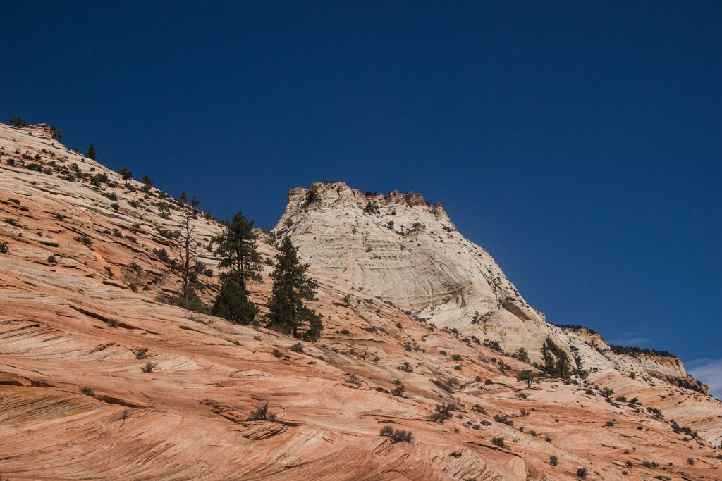
The geography in the east side of the park is very different. It is pretty much wide open, with sloping sandstone hills showing very distinct layers. Graham, Dean, and I had a great time scrambling on the rocks in a few places. We would have done more, but the heat limited our willingness to be out of the truck’s air conditioning for a longer time!
Photo credit: Dean SimonsPhoto credit: Graham Simons
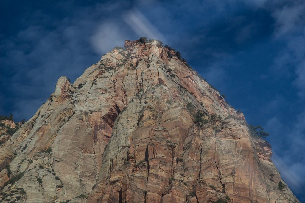
There are still peaks on the east side, but overall the area is much more open.
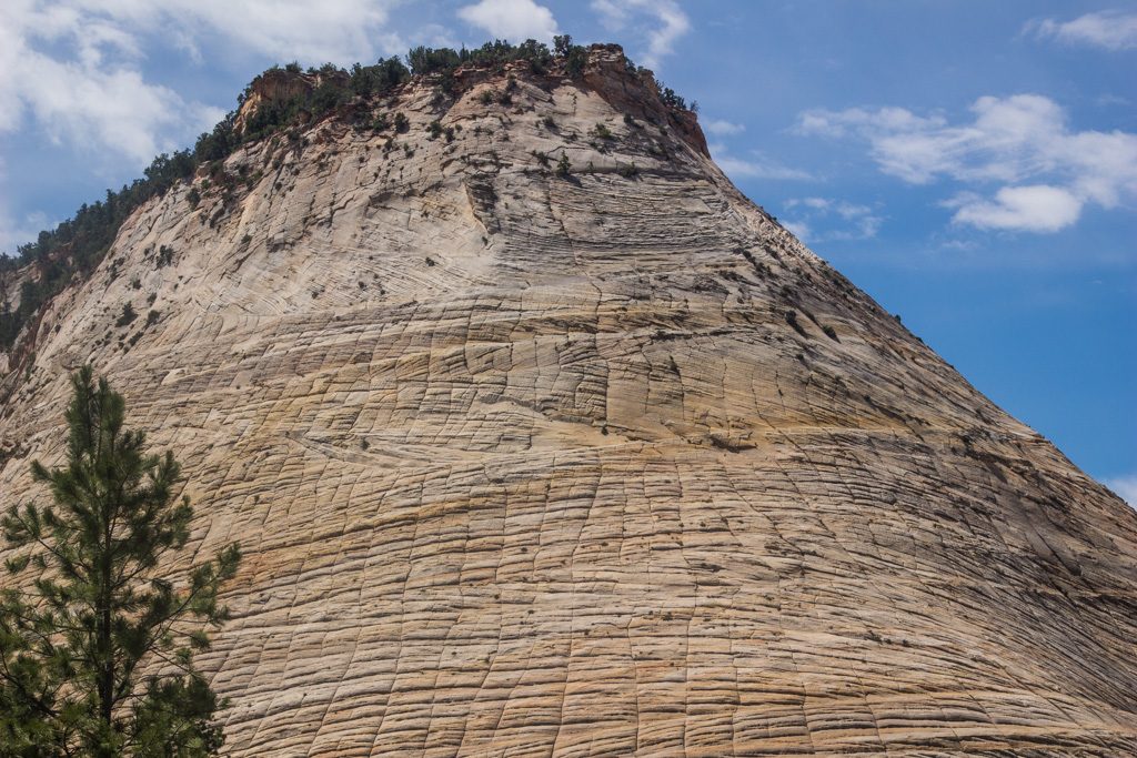
Photo credit: Dean Simons“Checkerboard Mesa,” named because of the pattern of fractures both horizontally and vertically. Photo credit: Dean Simons
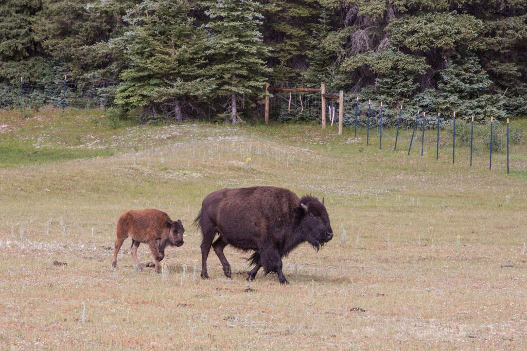
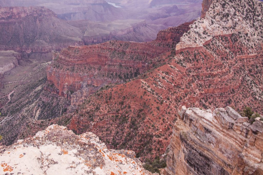
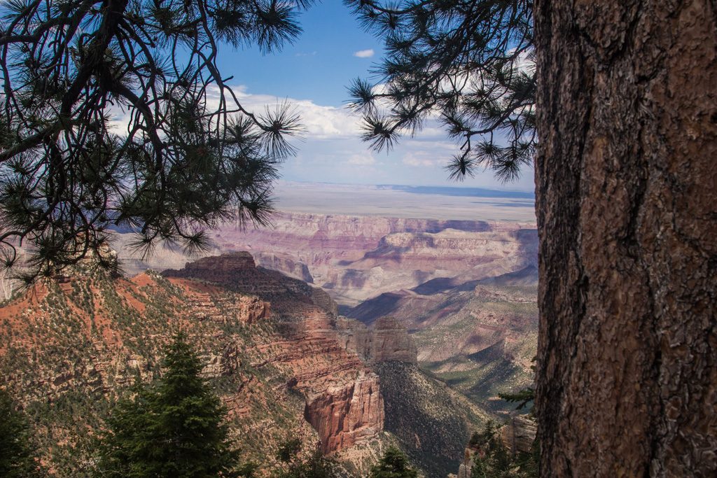
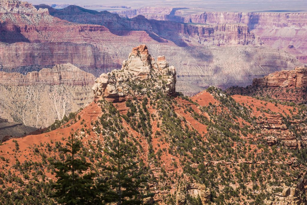
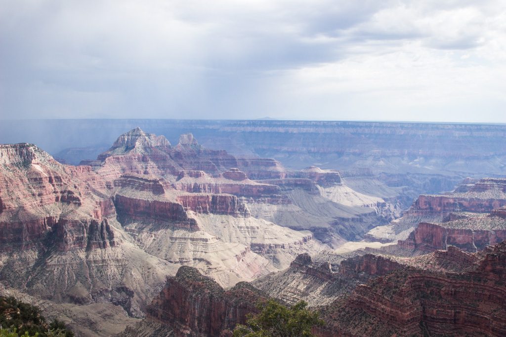
From Zion, we went to the north rim of Grand Canyon National Park. We camped in Jacob Lake about 42 miles north of the park–it was the closest campground with electric hookups (air conditioning is essential to us in Arizona in the summer). A sign near our campground at the start of AZ-67 said “This road is not plowed in the winter and not patrolled at night.” It quickly became apparent why. This is basically a very long driveway to the North Rim; there is virtually nothing for the whole distance.
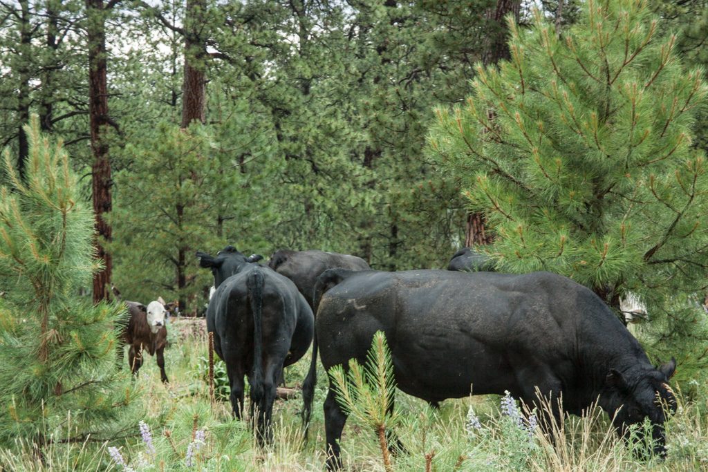
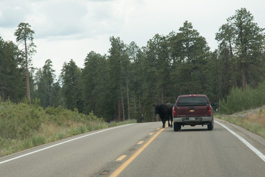
Nothing, that is, but some cattle and bison, and one gas station selling gas and diesel at obscene prices. A monopoly!
Bison mother and calf Photo credit: Graham SimonsCattle right next to the road… Photo credit: Graham Simons…and ON the road!Proof positive…Or is this better proof? Thanks for the picture, Graham! Photo credit: Graham Simons
Brother Graham framing up a picture of the canyon…
Photo credit: Dean Simons
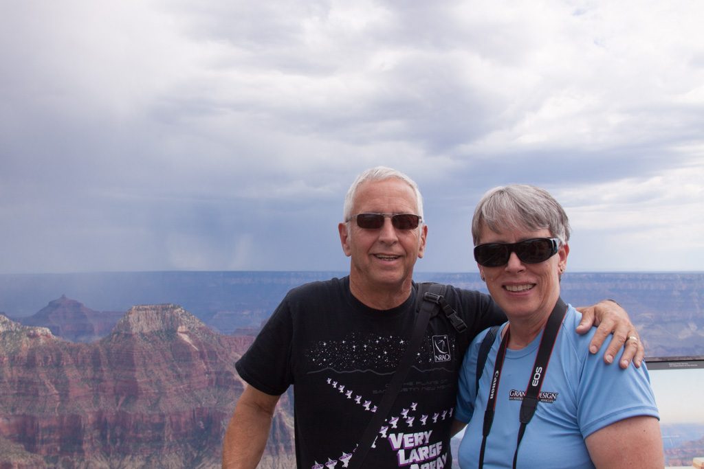
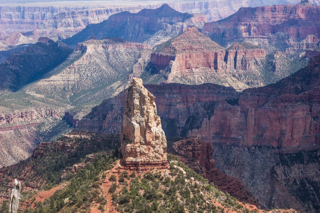
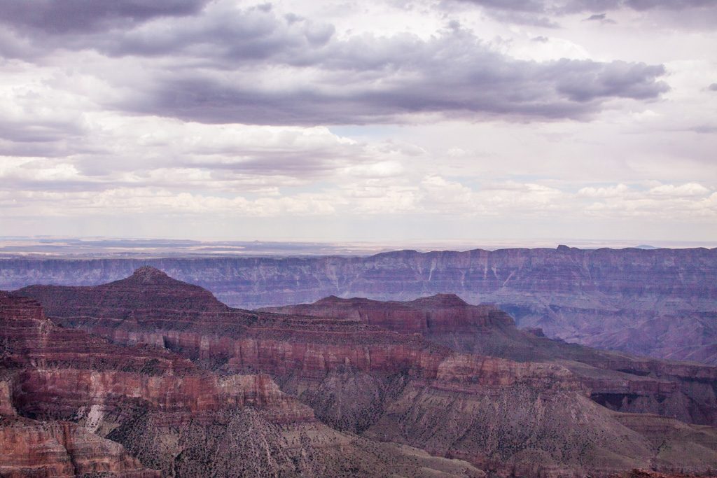
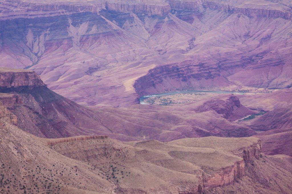
We’ll let the grandeur of the canyon speak for itself, as words can’t improve on it.
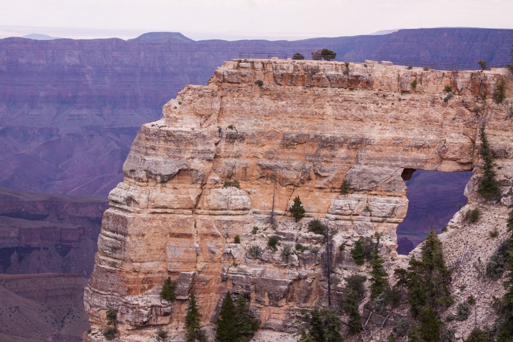
Photo credit: Graham SimonsPhoto credit: Dean SimonsPhoto credit: Dean SimonsPhoto credit: Dean SimonsPhoto credit: Dean SimonsPhoto credit: Dean SimonsA little bit of water, and a few million years go into making a canyon. In the center of the picture is the Colorado River, over a mile below us. Photo credit: Graham SimonsAngel’s Window. Notice the railing out at the end of the fin? Yep. We went out there! Photo credit: Graham Simons
Unbelievably, after visiting the Grand Canyon it was time for the last National Park of our time together. But first, a quick stop after driving to our next campground.
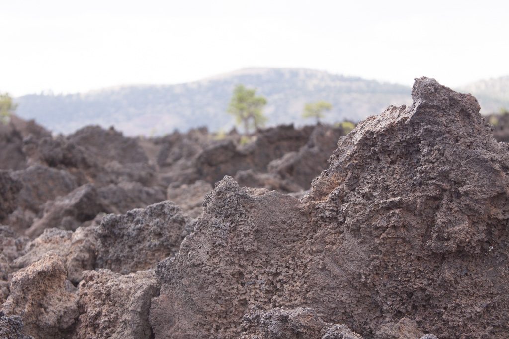
It is not often that you get to be next to a (dead? dormant?) volcano. Sunset Crater Volcano erupted about 900 years ago, so it is relatively new, geologically speaking. The cone is still covered with lava “pebbles.” (Sorry for not knowing the right term; somebody please fill me in.) Nature hasn’t taken the ground back with vegetation. Also, there are huge chunks of lava jumbled about. It is really quite interesting to walk through.
Photo credit: Graham SimonsMany acres of lava rubble Photo credit: Graham Simons
For many years hiking was allowed on the cone. This resulted in paths that were waist deep through the lava pebbles. Restoration efforts were made by shoveling many tons of pebbles back into the tracks. The scars from this are still slightly visible, but we didn’t get any good pictures of that.
The National Monument was created in response to a movie company wanting to dynamite the cone to create a landslide for a scene! The locals said heck no, and pushed for the creation of the Monument. Phew!
There are secondary outlets from the volcano, and their mounds are called “spatter cones.” They are very fragile, and many of them are no longer complete.
A partial spatter cone. Photo credit: Dean Simons
Nature is trying to re-vegetate the land, but it is slow going.
Photo credit: Dean Simons
Sunset Crater Volcano was named because later eruptions expelled a reddish, instead of black, rock, covering the rim and lower slopes with red. This reminded some of a sunset. Or so the story goes!
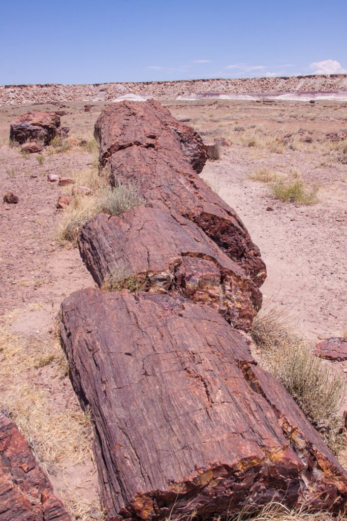
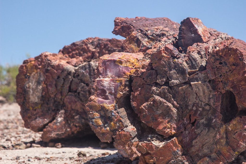
The calling card of Petrified Forest NP is of course the abundance of petrified wood—huge logs of rock. But it offers so much more: the remains of an ancestral Puebloan village, petroglyphs, the Painted Desert, and more.
Our last entrance sign picture!
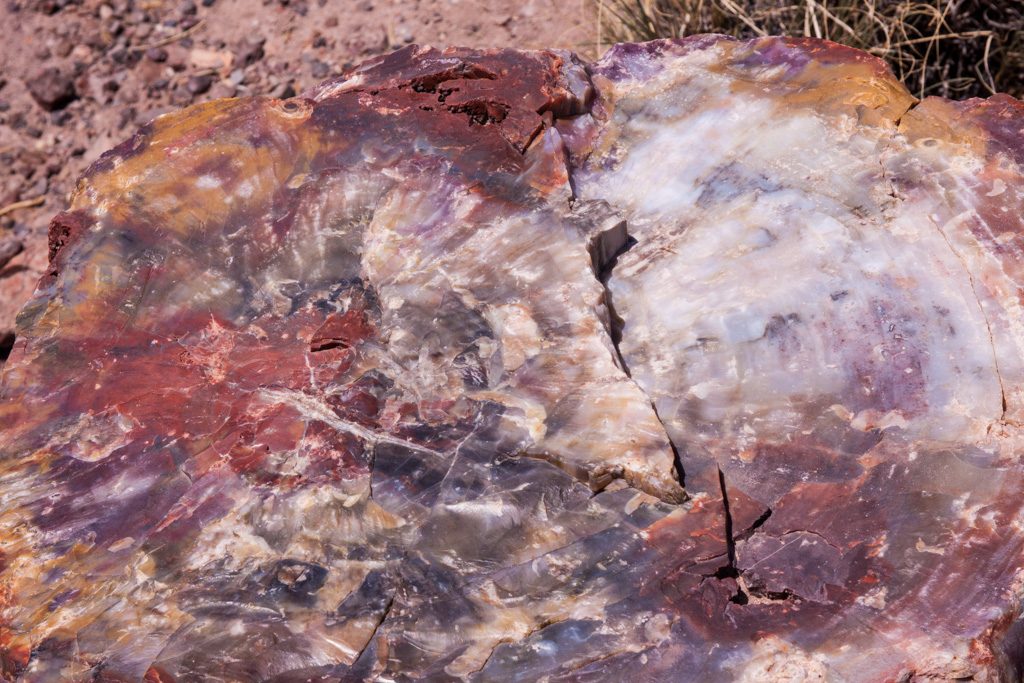
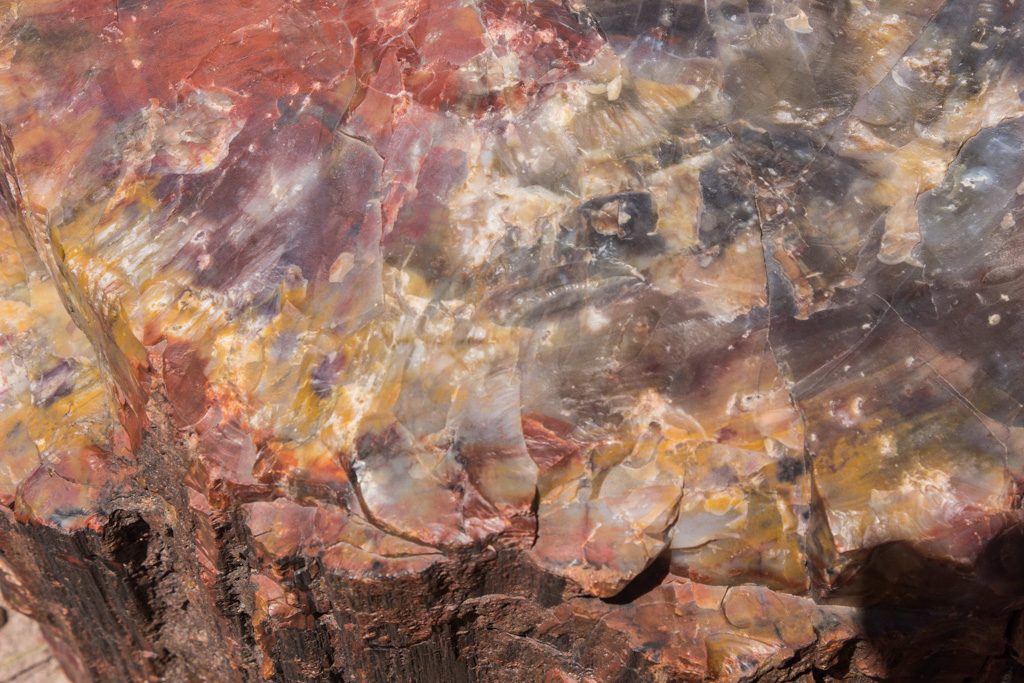
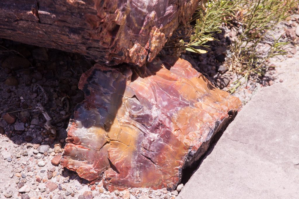
Petrified wood is formed as mineral laden water migrates into the cellular structure of the wood. Different materials such as iron oxide cause different colors. It is beautiful!
The pure white is uncontaminated quartz. Photo credit: Graham Simons Contamination sure looks pretty! Photo credit: Dean SimonsReds and yellows are from iron oxides contaminating the quartz. Photo credit: Graham Simons
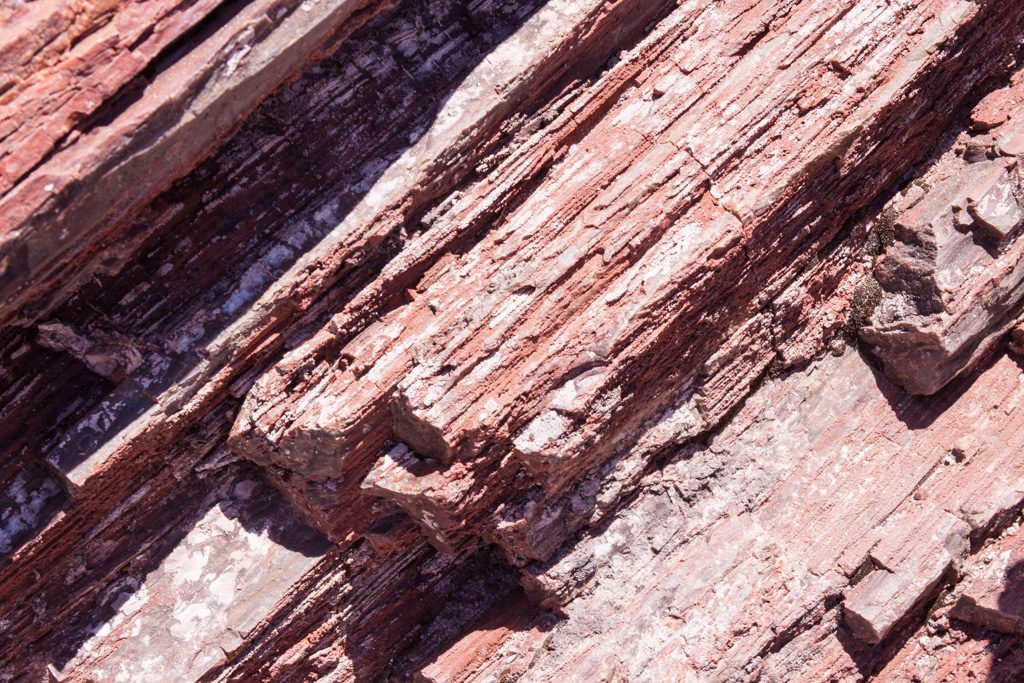
You can still see the tree’s structure preserved in the rock. The park said that there are some logs here where you can count the rings, but we didn’t find them.
Photo credit: Graham SimonsPhoto credit: Graham SimonsPhoto credit: Dean Simons
All of those pictures were taken walking through a one mile loop behind the visitors’ center. Then we drove through the park stopping at several of the view points.
Part of an 100 room village believed to be from the ancestral Puebloan people. The area was abandoned in the 1200s due to severe drought. Photo credit: Graham SimonsThe petroglyphs near the Pueblo village were varied and fascinating to check out. Photo credit: Dean Simons
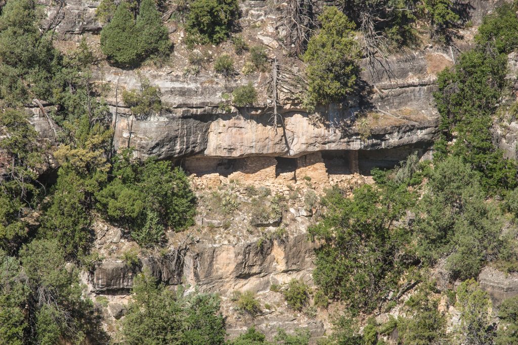
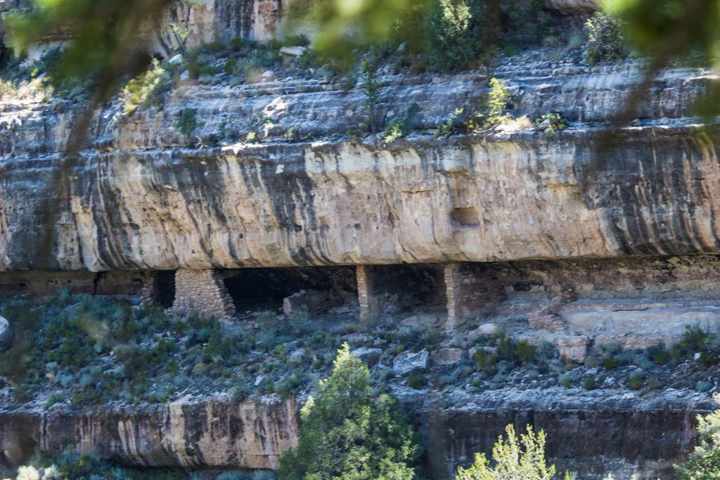
This was a short stop very near where we were camping, on the morning of our last day together.
Despite heavy looting in the late 1800s and early 1900s, many cliff dwellings still remain in this canyon.
Half way up the opposite canyon wall. How did they get there? From the top or the bottom?Lots of cliff above, and below.
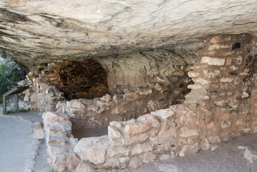
The “Island Trail” is a loop trail. When we were here several years ago in a February, the trail was only passable part way because of ice. This year the trail is only passable part way due to trail maintenance. Fortunately, it closed the other half, so across two trips Al was able to see the whole trail.
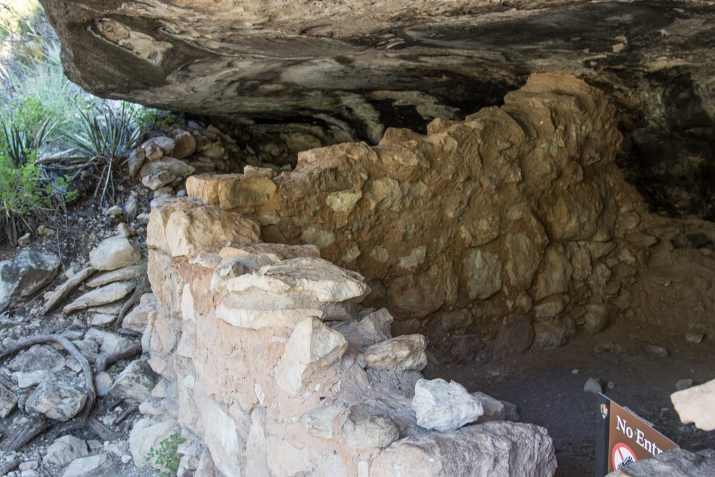
The side that is now open has much more extensive dwellings right along the trail. Some can be entered, some are posted to keep out
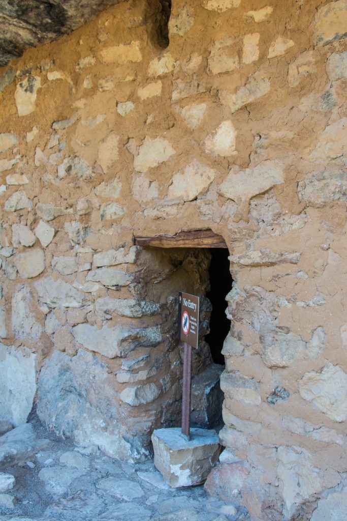
The trail goes right alongside these structures.Many of the structures were dynamited to make it easier to loot them. Sad. Notice the “No Entry” sign.A still-intact wall with entry… And a No Entry sign.
We have such easy lives. Imagine that you had to carry your food, and water up or down a cliff every day—several hundred feet of nearly sheer rock face, either way. How did they get Amazon deliveries? Oh… Wait.
Then we spent the rest of our last day together getting ready for the trip home and playing games. Then Al had to say “goodbye,” and drive us to the airport. It was a great visit with Graham and Dean, everything we’d hoped for and so much more!